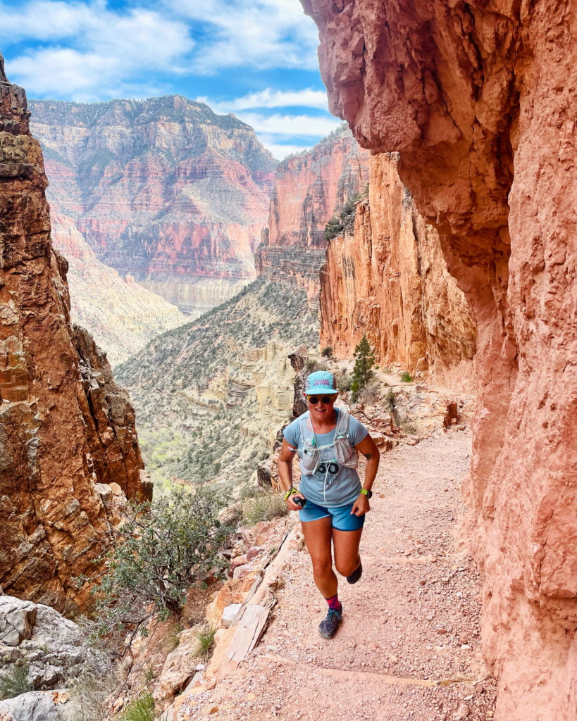
 Runner: Coach Natalie Collar
Trip: Grand Canyon: Rim to Rim to Rim
Date: 04/04/2022
Time to complete: 16 hours
Location: Grand Canyon, Arizona
Strava Activity Link: https://www.strava.com/activities/6933486256
Gear – What did you bring?
- Ultimate Direction Ultra Vesta
- 1.5L hydration bladder
- 500mL soft flask
- Katadyn 1L water bottle filter
- Altra Superior shoes
- t-shirt
- shorts
- light windbreaker jacket
- Coros Apex Pro Watch
- Trail Sisters trucker hat
Fuel – What did you consume and/or not consume?
- Spring Energy Awesomesauce (5)
- Honey Stinger Waffles (2)
- Honey Stinger Chews (3)
- Jolly Ranchers
- dried mango
- peanut butter-filled pretzels
- chocolates
- Spring Energy Electroride (1L total)
- drank almost 10L of water
Logistics – What kind of planning was involved for both prep and implementation?
At this time of year, the North Rim is still closed, so no parking or services are available there, which left two options for starting at the South Rim. You can either take the South Kaibab Trail or Bright Angel Trail down to connect it with the North Kaibab Trail. Since I didn’t have anyone to give me a ride in the morning or pick me afterwards, I opted for the Bright Angel Trailhead, because parking is right next to the trail, whereas South Kaibab Trailhead is a couple miles away from the parking. Distance-wise, South Kaibab is a little shorter than Bright Angel, but if you have to cover the extra distance on foot to the parking lot, it basically evens out.
I was staying in Flagstaff which was less than a two-hour drive from the trailhead, so I’d recommend staying here if you’re not staying in the Grand Canyon village.
There are water sources along the way at the various campgrounds along the route, but researching this information was difficult and unclear. When I did the route, the water sources were turned on at: Indian Gardens, Phantom Ranch, Manzanita, and this was just enough to stay hydrated throughout the day. My strategy was to fill up with as much water as possible when I came to a water source, especially as the temperatures warmed up.
Where to find the info on this
I found the route details on the Trail Run Project website and Strava. I recently found a Facebook Group for Rim to Rim to Rim info, including up-to-date water access info, and the name of the group is: Grand Canyon R2R2R Run! https://www.facebook.com/groups/grandcanyonr2r2rrun
What went “right” or at least how you expected it to go?
Route finding was pretty simple as I expected. There were more public restrooms than I expected, which is always nice for a long day on the trail, too. Nutrition and fueling went well, too. No upset stomachs, no dehydration, no falls or blisters (yay!), and STUNNING views along the way. The weather was also perfect, and even though it got up to 75-80 at the peak of the day, there were maybe 1-2 moments where I actually felt too hot. In fact, until 10 am, we weren’t even in direct sunlight, which was awesome (We started just before sunrise at 5:30am).
What went “wrong” or completely unexpected that you had to deal with?
My legs were actually pretty gassed after the initial descent of 6-7 miles, even though I was taking it easy, so dealing with the unexpected fatigue from so early on was a little challenging. I wouldn’t say I had the best day physically or mentally and almost nothing felt easy, but I definitely enjoyed being on the trail.
Lessons learned for either the next trip or another’s first trip?
- I ran out of water once, just due to being stubborn and ready to be done at the end. I passed through Indian Gardens, which is just under 5 miles from the top of the South Rim, and I thought I had 500mL left, but only had a couple sips. Luckily, I was with a friend who had a bit more water left, so we shared. It was also dark and temps weren’t too high.
- Another lesson for me was that 48 self-supported miles was just a tad too long for me. I’ve done several 20-30-mile self-supported runs, as well as many 50-mile+ races, so I wasn’t expecting this to be too different, but it definitely was! After 35 miles or so, I really just wanted warm food and an aid station, and would’ve paid so much money for a burger or ramen.
- Finally, this is definitely a route I will only be running once, but there are so many other adventure routes in the Grand Canyon that I’d love to put together a shorter one and continue exploring this beauty.
Everything else!
- This was a bucket list adventure run for me–48 miles, 11k of up and down–so I feel incredibly proud to have completed it! I had been to the North Rim once before, but only hiked down a mile or so, so almost the whole route was completely new to me. It was such a treat to see such gorgeous and unique views throughout the whole route. We had ideal weather and trail conditions, too, so I highly recommend this route at this time of year before it gets too hot. I did heat train for this run, by hitting the sauna and hot yoga a couple of times, but I was totally unaffected by the heat.
- We saw quite a few other parties of runners along the route, either completing the full double crossing or some other variation. We also saw many hikers and one party of mules, so although it was a long self-supported adventure, it definitely wasn’t a remote alpine-esque route where there are only a handful of people on the trail.
- I think I will remember the feeling of being so small compared to the canyon walls the most. You look up, and you can’t even see the top of the walls. While you’re up higher in the canyon, and you look down, you can’t even see the bottom. I don’t think there is a name better and more fitting than the Grand Canyon. It was unlike any feeling I’ve had while running in the Colorado mountains.
- Finally, my recovery from this run has been pretty ideal. The initial day or two of soreness, fatigue, and stiffness where there, but after a day in the car and an epsom salt bath, most of the soreness has dissipated, and it feels like I will be back running soon!
Natalie is a coach with Team RunRun. To learn more about her or work with her, check out her coaching page.
Additional Trip Photos:


