Get all the Eugene Marathon info you need to be your best on race day. Race reports, a pre-race zoom call, and more!
Eugene Marathon 2018
1. Pre-Race Zoom Call
With the Eugene Marathon coming up soon, we’re bringing veterans and first-timers together to ask questions, share insights and build some excitement heading into race weekend!
Date: Thursday, April 16, 2026 Time: 8pm PST Location:Call Recording
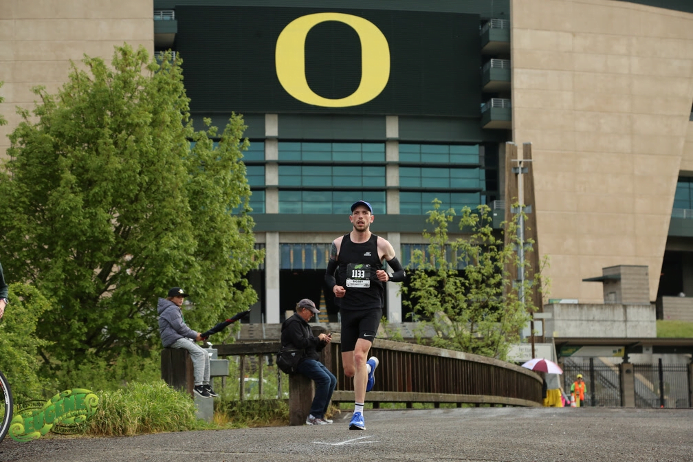
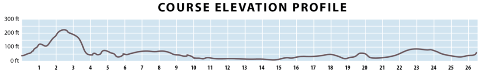
After you split up with the half marathoners, around mile 12, the crowd dwindles, which is a pro for some, a con for others, so be prepared either way
Likely that it will get fairly warm if it’s a clear, spring day
Lots of sun in a lot of the race pictures, so be ready for sun exposure for a lot of the miles
Bridges in the race can seem like quite difficult uphills, especially later in the race
If you’re used to hills, the hills won’t seem big, but if you’re expecting a completely flat course, it will seem hilly
Very well-organized race
Not tons of spectators out on the course, so be ready for some quiet miles, especially after mile 12, which again, is a pro for some, con for others
Miles along the bike path on the river can be really pretty, but also can last forever if you’re struggling, and because you can see others on the other side of the river, ahead of you. Have a strong mental game for the second half given that.
Last water is at mile 24 – keep that in mind if you drink a lot in the final miles
Photo: Eugene Marathon
4. Race Reports:
From Coach Chris Poole https://teamrunrun.com/eugene-marathon-race-report-chris-poole/
In this post, find all the Boston Marathon race info you could possibly want to know. Read on for our runners’ reviews of the course, the wait before the race, the gear for bad weather, and more!
“The first few miles of the race can feel cramped and narrow. I would avoid wasting extra energy by trying to weave around people. Things will open up!” – Coach Elaina Raponi
“I’d avoid deliberately pushing the pace early on the downhills in an attempt to “make up time” for the Newton Hills and Heartbreak Hill. You want to listen to your effort and make sure you’re not ruining your quads before the hard part even starts.” – Coach Elaina Raponi
“If you’re in wave 1 corral 1, you may want to consider running with wave 1 corral 2. The reason being that they keep everyone in corral 1 off to the side while the elite and professional fields start which makes it more cramped than the corrals themselves. It could be more comfortable to sit in one corral later.” – Coach Tavo
Once you get off the bus in the Athletes’ Village, try to find a covered spot to sit and rest as much as possible. Don’t feel like you need to rush to the corrals unless you’d like to do a warmup jog. I typically recommend walking comfortably and taking advantage of the free sunscreen provided there as well!” – Coach Tavo
“Your legs can take a lot of pounding from the first 5km with a significant downhill and going out quick. I always suggest taking that first 5km almost mind-numbingly easy, navigating the crowds as best you can. The Newton hills aren’t all that scary if you’ve been conservative up to that point, and if you’re feeling good at the top of Heartbreak, that last 10km downhill is something incredibly special to be able to race to your fullest.” – Coach Tavo
“The absolute best part of the race is the crowd and the atmosphere. There are almost no silent parts of the race. You have support the entire way!” – Coach Dakotah Popehn
“When you’re training you have a lot of time to think about your race. It is super fun to think about all of the ways the race could go well and imagine all the great possibilities that could unfold. And I encourage you to visualize those situations and enjoy that time. Also take time to imagine the weather being too warm, too cold, and too wet. Think about how you will feel and how you will adjust not only your race, but also your mindset. With all of the training you put into longer races you have time to think through thousands of scenarios.” – Coach Dakotah Popehn
“If you have a ride to Hopkinton in the morning, and don’t need gear check, getting dropped off at the Hopkinton shuttles is super easy and lets you sleep in a little longer.” – Coach Brandon Tower
This is Team RunRun’s Shamrock Run Race Info, the place for you to learn and prepare with tips and insights to run your best at this classic Portland, OR race weekend!
1. Pre-Race Zoom Call
With the Shamrock Run weekend coming up soon, we’re bringing veterans and first-timers together to ask questions, share insights and build some excitement heading into race weekend!
Average high: 54°F to 57°F (12°C to 14°C) Average low: 33°F to 41°F (1°C to 5°C)
Half Marathon Course Tips:
Miles 1-4. It’s very flat.
Miles 4-7. Gradual uphill . Climb up Terwilleger from 49 Ft elev to 340 ft elevation. 7 miles will be right around the turn around point at the top before you come down
Mile 7-8- Toughest and slowest mile of the course! You will go down hill slightly for a quarter of a mile before making a sharp turn left and then making your way up SW Capitol High .3 of a mile before making the turn to go up terwilleger hill. The uphill lasts another ½ mile until you hit mile 8. You will climb 130 ft from 7.2 to 7.5, and then get up to 500 Ft elevation at the top of the hill, right before mile 8 marker. Climbing a total of 160 ft for that short steep segment. Make sure you run through the top of the crest of the hill! Very easy to get tempted to slow down, but your legs will work through that lactic as you continue going past the crest.
Miles 8-10. You are riding along the top of Terwilleger boulevard! With the exception of 8.6 to 9 miles, this part of the course is all downhill. The bottom of the downhill is at 10.2 miles , which is at 174 Ft elevation. This is the part of the race where you should begin pushing at your goal pace or a little quicker
Mile 10 to 11.3- this stretch is from the bottom of the terwilleger hill, and making your way back south on Terwilleger. This is the last bit of the course that has a slight uphill (ALbeit, it is very gradual. 175ft elevation to 249 elevation
11.3 to finish– You will make a u Turn to go north on Naito Parkway. You will go through a car tunnel underground for a short segment but make your way back to the finish line. This is ALL downhill with a slight raise up into downtown where you can see the finish line. The finish line will seem closer than it appears! You will come back to the atmosphere in downtown by the race festival and hear a bunch of music. At this point in the morning, you will see many more people making their way downtown for their races later in the day so will get a lot of their encouragement! Gauge your effort relative to the finish line, but let it rip, have some fun and enjoy the finishing sprint!
Shamrock Run Fest 8K
START TIME: 9:00 AM
Start: SW Naito Parkway & Pine Street
Finish: SW Naito Parkway & SW Harvey Milk St
Course type: Out and BackCourse Map and Elevation Map:
Average high: 54°F to 57°F (12°C to 14°C) Average low: 33°F to 41°F (1°C to 5°C)
8k Course Tips:
This is the race that will get the most elite/sub elite athletes for the event. The 8K course is pancake flat, out and back, and the grand prize for the top male and female is your weight in beer! Yes, your weight in beer! With that being said, the start will be super hectic! A lot of people will try to get out super hard at the start, and the past few years have caused some crashes.
Starting line chaos!
THE START IS Fast! You will want to gauge your pace here right at the start. I finished my race last year in 5:32 pace, but started my first mile under 5:10 and felt pretty effortless getting out. The reasoning behind it is that there are a lot of groups of runners running the same paces together, which makes the effort feel not as strenuous. I ended up getting tired and slowing down a bit the last 3K of the race.
The course goes out approx. 3.8K, and then you make a turnaround to run approx 4.2K back to downtown.
There will be spectators very frequently throughout the entire course! It is very accessible to the downtown race festival, and a short walk to some good viewing points.
Note that the Finish Line is a few blocks further south from the starting line. When you start the race, it is about 0.4 miles to the Steel Bridge. As you are gauging your kick, you will run underneath the Steel Bridge, which is 0.5 away from the finish when you come back. Make sure to note that as you time your finishing sprint
Average high: 54°F to 57°F (12°C to 14°C) Average low: 33°F to 41°F (1°C to 5°C)
5k Course Tips:
This year there is a course change! Instead of the course going south on Naito and hitting a slight uphill until the halfway point until turning around, it begins going the opposite direction north on Naito, into the industrial district. The change makes the course profile super flat and a big PR opportunity!
The course goes out approx. 1.2 Miles before you do a 180 degree turn to come back to the downtown area. You will pass by the starting area at 2.4 miles
You will run another 6 blocks (0.3 miles approx) until you hit SW Taylor St. You will make a right on Taylor St, Run west 2 City blocks until you hit 2nd street, Make a left on 2nd street. Then Make a left on Salmon until you get back to Naito Parkway (2 blocks east). You will then make a left on Naito. That corner on Salmon and Naito will be the 3 mile mark. From there , sprint the last 200ish meters to the finish!
4. Registration, Pre-Race and Post-Race
Registration
You get a free Long Sleeve shirt courtesy of the race (Until stock runs out)
If you want to join a team, here are some of the perks that come with joining a team! First, a $4 discount on entry! If you do want to join a team, make sure that you connect with a captain, or make your own team and invite people to join you on race day! Depending on how many people you have on the team, you can earn perks such as Race packet mailed to team captain, earn extra drink ticket at the post race festival, Placement in the team village and more! Shamrock Run does have certain deadlines to get the perks.
Note- 40 team members are required to gain access into the security guarded team village. This is an awesome perk (In my opinion) to be able to gather as a team pre and post race, have a spot to place your bags you may have vs. waiting in the gear check line, and just a great spot to hang out!
Handcycle/Wheelchair athletes are able to participate in the Shamrock Run
Registration (No Perks) Deadline: March 1 (registration only—no team perks included)
You can pick up your packet at the Expo for free, or pay $20 additional at checkout to be able to pick up the day of the race.
The expo is at the Oregon Convention Center. There is ample street parking and parking within the convention center, but rates can run $10-$20 an hour depending on how long you spend at the Expo.
Race Day
Before you go, make sure to study the best parking spots around the Portland Downtown area. Parking garages will fill up early (very little on street parking, and do not recommend based on other foot traffic in the area). If you have to park further away from downtown, make sure you have enough time to get to the starting area and gear check!
It is usually very cold in the morning. Make sure you have the warm clothing you need to stay warm prior to your race
If you are dropping items off at Gear Check, make sure that you use the bag provided when you pick your packet up, and ensure that you give yourself enough time before your race to drop it off at the booth. The lines can get super long, so just make sure to keep that in mind
Post Race
Post Race Finishing Chute: Lot’s of snacks and goodies provided! Anything from bananas, protein bars, gatorade and other items!
The big attraction is the Beer Hall , which is easily noticeable by the big white tent and alcohol signages. There will be security checking ID’s and giving you a wristband confirming you are of age. There are bands playing music until early afternoon, and a lot of food vendors around to help you with refueling post race! Take advantage of the great vibes, relax, and enjoy yourself after a hard earned run, hopefully with a PR, but at the very least great times had! Make sure you have your ID, card or cash, and you are ready to roll!
5. Shamrock Run Coaching Info
At Team RunRun, we have 100s of wonderful, experienced coaches ready to help you crush your goals, regardless of your ability, budget, or lifestyle. Specifically, for Shamrock race advice, here are some coaches to start with:
With the Mesa Marathon coming up soon, we’re bringing veterans and first-timers together to ask questions, share insights and build some excitement heading into race weekend!
Average high: 79°F (26°C) Average low: 53° F (12°C)
Course map and Elevation – thank you to Derek Siebert for the Strava info!
Tips from Coaches and Runners:
Registration – Bibs can be personalized if you register by a certain date. I chose Team RunRun but you can choose your name or similar.
Expo – No race day packet pickup and is held in a retail complex. Very well organized, outdoor/indoor setup with easy parking. Good course information, maps, bus schedules etc.
Race Day:
Must park near finish line and take school bus to start. I don’t remember if there were assigned bus times, but I always like to be early. Ride up was close to an hour if I remember correctly. I don’t recall being able to wait on busses so be prepared to dress warm. I believe the roads are blocked off to anyone but busses so I don’t think getting dropped off is an option.
When you get up there, it’s dark and cold. Race started at 6:30 and I think I was there by 5:30. Time went by predictably slow. Decent amount of toilets and propane heaters, but as more busses got there, it got pretty crowded. Decent ability to warm up.
Entertainment. Through their app they had a landmarks and pace feature that you could listen to. The landmarks were pretty interesting, but timing/location were off a bit. Timing was all over the place and I eventually turned it off.
GPS – One of the most accurate I’ve ever done, finishing in 26.22. Splits with Garmin were very close to physical markers.
Miles 1-4. It’s still dark. DARK. No spectator access so it’s eerily quiet with the pitter patter of carbon shoes in cadence. Road starts as both lanes and then goes to 1 lane. Cones randomly appear out of nowhere and runners try to communicate so you don’t trip. It’s crowded. Recommend throw away headlamp, especially if you are near front of pack, assuming same race start time. Similar feeling to first miles of Boston where it’s hard to run your own race.
Miles 5-6. Gradual uphill but actually feels like a good change of pace before more downhill miles.
Miles 7-20. Gradual downhill and getting into the city. Once you get onto McDowell Rd, then, Val Vista Dr, and long stretch on Brown Rd, the miles are pretty boring. Residential and retail with lots of 5 lane roads/stop lights. Plenty of running room here.
Miles 20-finish. These miles have a few more turns and are flat, but seem uphill. Spectators increase a bit, but you need to rely on your own motivation overall.
While it’s only mid 50s at finish, the desert air zaps energy and hydration. It was my first run of any length and I was pretty dehydrated despite not pushing for a PR
Post race. Quick finisher chute, snacks/drinks as expected. I stuck around for other runners in the 4:30 range and it seemed well organized and supplied. Cool finisher print out that congratulated me on BQ.
Aid stations. Nothing memorable good or bad. Normal distribution and water/electrolytes. I think they were staffed well. I carried nutrition so I’m unsure what was offered, if anything. I did not carry my own hydration, but many did.
Overall a very well organized race. First half has some amazing views, but second half looks like the same landscape for a long time. Biggest regret was getting there so early and being cold and not having a headlamp. Not tripping in crowded first few miles was an accomplishment. I think it’s a great tune up marathon for Boston from a course profile stand point to get used to pounding quads early, but lacks any uphill except a couple early uphill miles.
From RunRunner Derek Siebert
“Arrive earlier than you think as there will be cars lined up to the buses. The race was delayed last year (2025) because of traffic on the highway.” – Coach Brant Stachel
“You’ll be starting in the dark so it may be helpful to practice running in the dark. The streets have decent lights but it is a different feel for your pace.” – Coach Brant Stachel
Runners staying warm with heaters before the race.
Starting line and it’s definitely dark!
Finally seeing the sunrise during the race.
3. Race Reports
Want even more intel on the Mesa Marathon? Read some of the race reports from Team RunRun coaches:
From David Ha: https://teamrunrun.com/mesa-marathon-race-report-david-h/
RunRunner Derek Siebert (in white) with other marathon finishers.
4. Shakeout Run
Shakeout Run
Date: Friday, Feb. 13, 2026
Time: 8am (race expo starts at 9am).
Location:Tempe Beach Park (10 minutes from the expo, has parking and there’s a paved path along both sides of the lake with a pedestrian bridge at one end)
Distance: 5k easy run – all paces welcome. Option to run farther (it’s an out and back route).
Optional post-run social: Bones and Bru (.3 miles from the run start so people can drive or walk. Serves smoothies and coffees and makes dog treats)
5. Mesa Marathon Coaching Info
At Team RunRun, we have 100s of wonderful, experienced coaches ready to help you crush your goals, regardless of your ability, budget, or lifestyle. Specifically, for Mesa Marathon race advice, here are some coaches to start with:
3 Bests – What aspects of the race did you like the most?
Low key marathon: It felt like a long run, out on the trail, with a bunch of friends.
Finish line atmosphere: Warm food: chili, hot dogs, soup, vegetarian options, and beer with a few space heaters to stay warm.
Easy spectator access: Family and friends can follow along for moral support and photos.
Not so much – Aspects of the race that didn’t do it for you
None of the streets, or driveways, are closed, so stay aware of cars and bikes.
Lake Washington Blvd trail needs some work. Many roots have caused the asphalt trail to buckle and crack; at times it was tough to run on.
Aid stations are minimal. Only water, electrolyte drinks and a few small snacks. Bring your own gels and any extra calories you would need.
Weird factor – What’s the weirdest thing about this race?
This is the course that “The” Seattle Marathon used to use. It started in 1985 when the Seattle Marathon changed courses and moved from Saturday to Sunday of Thanksgiving weekend.
Highlights of your race – What did you do well and enjoy about your race in particular?
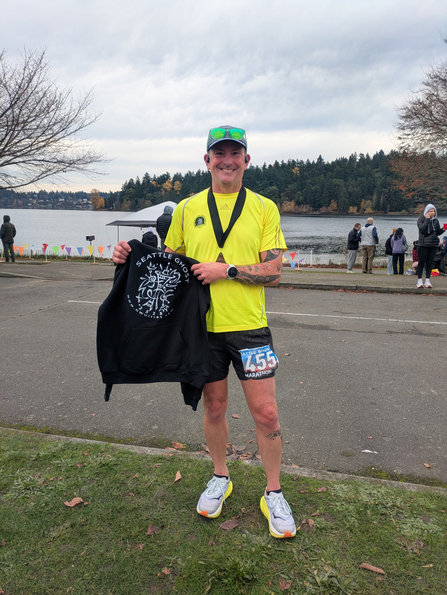
It had been quite a while since I had run a marathon on roads; I enjoyed finding a pace that was challenging, then holding onto it for the whole 26.2 miles. I finished strong and didn’t beat myself up too much so I could run “The” Seattle Marathon the next day!
Lessons for others – Share your pro-tips on the race to help the next runner
A lot of marathons are “flat” but the Seattle Ghost Marathon is particularly so. No bridges, overpasses or any hills to speak of. So prepare your legs (and mind) for some very repetitive work.
Lessons you learned that will help you next time around
As a result of enjoying the morning and having fun out there, I forgot to stay ahead of my calories. With minimal aid stations (one at the start/finish that you pass by a few times, plus another small one) and not much to choose from at them, I didn’t eat enough. Next time, I would carry more calories on the run with me. And I would be more diligent about getting calories in.
Most important course specific knowledge to know about the race
The course is a very flat and fast certified Boston Marathon qualifier. But there is more than a mile of the Lake Washington Blvd Trail that is super bumpy from tree roots, making it tough to run on.
Aesthetics – Is it a pretty course?
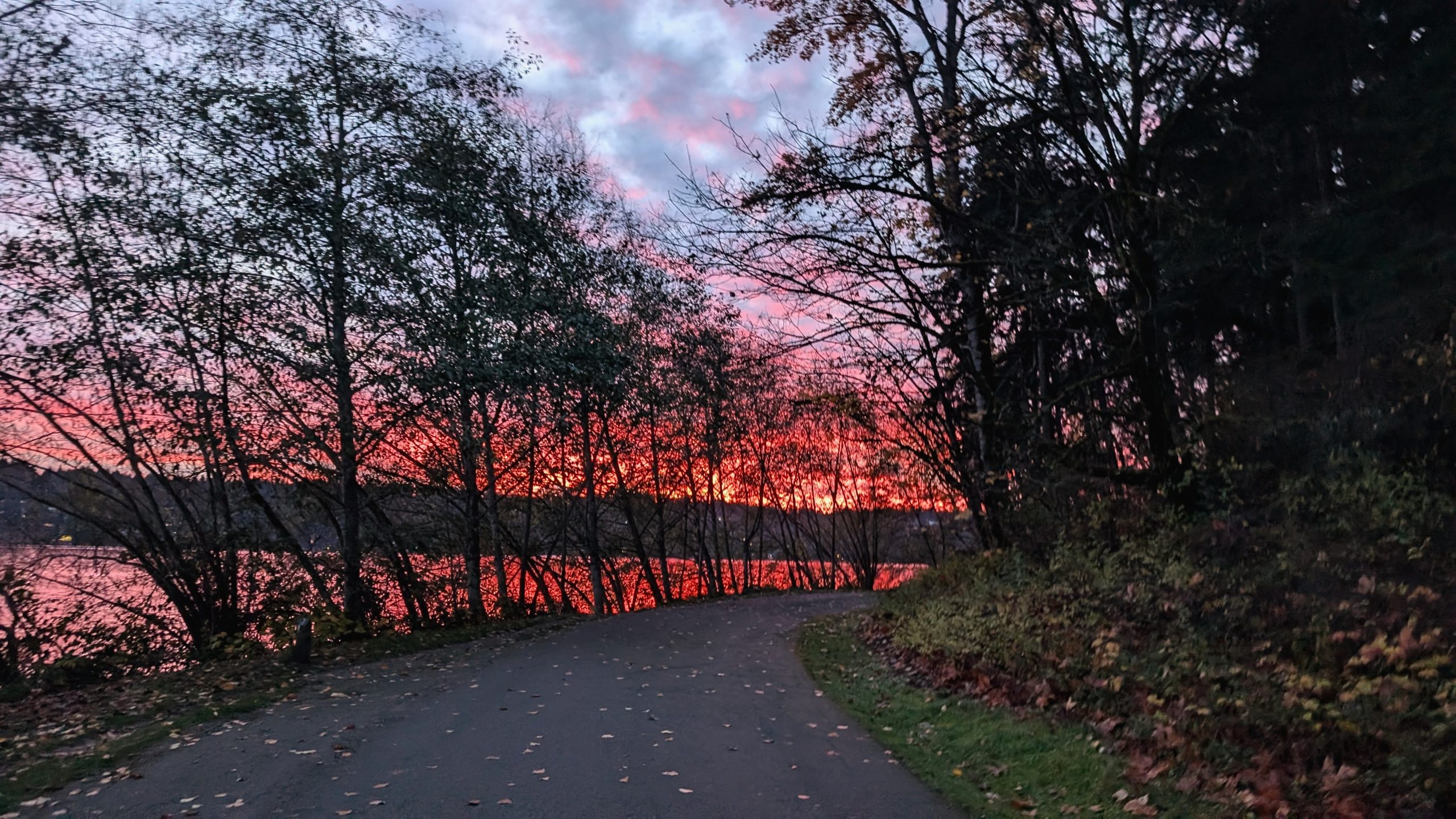
The Seattle Ghost Marathon starts at sunrise with a loop of Seward Park that sticks out into Lake Washington, giving way to some spectacular sunrise views. The rest of the course follows the trail along the lake and near some beautiful homes, showcasing great vistas across the lake to Mt. Rainier and the city of Bellevue.
A spectacular view of early sunrise across Lake Washington at the start of the Seattle Ghost Marathon.
Difficulty – Is it a tough course?
No! As far as marathons go, it is a very easy course. Only some very moderate vert, I think less than 300 feet of climbing for the whole Seattle Ghost Marathon. And with not many people running it, there is no congestion along the course.
Organized and well run – Did it feel like a well-oiled machine or were they flying by the seat of their pants?
For a very small and low key event, it is run very well. From e-mails to the marking of the course, the finish line and timing, it all ran perfect.
Competition – Is there a strong field?
No. The Seattle Ghost Marathon isn’t very competitive, it’s more of a fun challenge. If you want competition, the Seattle Marathon is the next day and it can be pretty competitive.
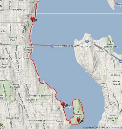
The Seattle Ghost Marathon course map.
Logistics – Does it require a special handshake, registration a year in advance, hotels all booked? Give us the low down on the nuts and bolts of making the race happen.
While the website is pretty minimal, it is easy enough to find. And it doesn’t sell out or anything. A local couple put the race on and it’s all not-for-profit.
Aid Stations – Standard fare or anything special to know about the aid stations in terms of what’s available or when?
Very basic aid stations. The electrolyte drink was something I hadn’t ever had before, and it didn’t work for me. There are no gels at the aid stations, just some basic “real food” options like chips and gummy bears.
Weather and typical race conditions
The end of November can be pretty rough with rain and such. This year, it was just cold enough that I needed some lightweight gloves despite running in a short sleeved tee. I’d advise runners to always bring rain gear and layers just in case it gets rainy. The Seattle Ghost Marathon starts at 7 am, so it’s just getting daylight when you start, but not dark enough to need a headlamp.
Gear – Did you need anything special or is there anything you’d recommend for the next runner?
Nothing special. You pass the start/finish three times and you can have a drop bag there if you want to grab or drop extra layers or whatever.
Spectators – Is this a friendly course for your friends?
The Seattle Ghost Marathon is super friendly for family, especially because it runs alongside a very accessible road. Your friends can meet you at basically any point along the course (or at one of the many parks the course goes past). One benefit of the course not being “closed”, is that family and friends can walk along the path and meet you as you come by.
How’s the Swag?
There was a cool design on a basic hoodie, alongside a nice and unique little medal with a built in bottle opener. Not bad for the low cost of the race.
The Overall Score – How many stars do you give this race and do you recommend that others run it?
5/5! If you are looking for a low key, friendly, marathon, and you’re okay with not a ton of aid or closed streets, the Seattle Ghost Marathon is a fantastic race!
Michael Linscott is a coach with Team RunRun based in North Bend, Oregon. Michael works with a wide range of athletes: from new runners following a “couch to 5K” plan, to experienced ultramarathoners preparing for a gnarly 100 miler, and everyone in between.
A Coach’s Guide to Running 48.6 Miles at Disney World
Every January, thousands of runners head to Walt Disney World to take on one of the most unique endurance events in running: the Dopey Challenge. Four races in four days — a 5K, 10K, Half Marathon, and Marathon — adding up to 48.6 miles.
It’s a celebration, an adventure, and for many runners, one of the most demanding physical and logistical challenges they will ever take on. Having coached and worked with Disney runners, and completed the challenge myself, I’ve seen firsthand how much more goes into Dopey than just mileage. It requires strategy, mindset, discipline, and an understanding of the environment you’re stepping into.
Whether you’re taking on Dopey for the first time or returning to earn another set of medals, this guide will walk you through what makes the challenge unique and how to prepare for it with confidence.
What Makes the Dopey Challenge Different
On paper, 48.6 miles might look similar to an ultra-distance weekend. But Dopey is its own world. What sets it apart:
1. Four Consecutive Early Wake-Ups
Runners wake up around 2–3 a.m. for four straight days. The cumulative fatigue from lost sleep affects race performance just as much as the miles.
2. Theme Park Time Matters
Runners participating in one of the Dopey Challenge’s many races.
Many athletes walk 10–15 miles per day around the parks before or after races. It’s fun, but it adds to the load.
3. The Courses Favor Patience
Disney races require pacing discipline — the temptation to stop for photos, character lines, and the excitement of running through theme parks can drastically change pacing and effort.
4. Recovery Becomes a Skill
You finish one race only to prep for the next. Managing inflammation, nutrition, rest, and mindset over four days is part of the event.
5. The Marathon on Day 4 Hits Differently
Even experienced marathoners often describe the Day 4 marathon as uniquely challenging because of accumulated fatigue from three prior races. Dopey is a test of endurance, but also strategy and self-management.
Training Approaches That Make a Difference
1. Train for Cumulative Fatigue
It’s not just about your long runs. To simulate Dopey conditions:
The start of the Walt Disney World marathon.
Include back-to-back training days
Occasionally add a shorter run after a long run
Practice waking up early for select long runs
This prepares your body (and mind) for multi-day efforts.
2. Build a “Sturdy” Base
Runners benefit from:
Consistent weekly mileage
Strength training to support durability
Practicing walk breaks if using the run/walk method
Gradual progression, not big mileage jumps
A strong base = fewer surprises on race weekend.
3. Focus on Recovery Habits
Before race weekend even arrives, runners benefit from:
Prioritizing sleep
Dialing in fueling strategies
Practicing quick recovery routines
Learning how their body responds to back-to-back stress
These skills matter just as much as miles.
4. Practice Pacing Discipline
The 5K and 10K are tempting to run fast — but pacing early protects the rest of the weekend. Training with intention helps you know what effort feels like on tired legs.
Dopey Challenge Weekend Logistics Runners Often Overlook
Disney races are as much logistics as running. A few important considerations:
1. Transportation & Timing
Walt Disney World Marathon course.
Buses and shuttles start early, and long walks to the start corrals can surprise runners. Arrive early enough to stay relaxed.
2. Corrals Matter
Starting placement affects pace, crowding, and the number of character stops you can make without feeling rushed. Submit proof of time when possible.
3. Weather Is a Wild Card
January in Florida can mean:
Hot and humid
Cold and windy
Thunderstorms
Or perfect race weather
Plan fueling and hydration for heat, even if the forecast looks mild.
4. Managing Park Time
How much time you spend on your feet matters. Many runners underestimate park walking — and it adds up quickly. Plan your days with intention.
5. Post-Race Recovery Routines
Ice baths, stretching, rest, and consistent fueling can make the later races feel drastically better.
Starting the Marathon on Tired Legs
The marathon is the final exam of the Dopey Challenge. Three races are already in your legs, and the excitement of running through all four parks can give you a mental boost — but the fatigue is real.
Common experiences on Day 4:
Heavier quads than expected
Feeling strong for the first 8–10 miles
Hitting “the wall” earlier than on a standalone marathon
Needing to rely on fueling and pacing discipline
Runners who succeed often:
Stick to a conservative first half
Fuel early and often
Keep moving between character stops
Break the race mentally into sections
Know that the fatigue is normal — and temporary
It’s one of the most rewarding finish lines in running.
Runners meeting Disney characters during the Dopey Challenge weekend.
Mindset: The Secret Ingredient to completing the Dopey Challenge
TRR athlete, Dafne, with all her medals from successfully completing the Dopey Challenge.
Dopey is not just a physical challenge. It’s emotional, mental, and sometimes surprisingly spiritual.
Runners learn to:
Trust their training
Stay patient during the highs and lows
Adjust expectations when needed
Find joy in the journey
Stay flexible despite race-week logistics
Celebrate every step
There’s nothing quite like earning six medals, especially when each one represents discipline, consistency, and resilience.
Final Thoughts
The Dopey Challenge is one of the most unique and joyful endurance events in the running world. It requires preparation beyond traditional marathon training — from managing logistics to navigating back-to-back race fatigue to balancing the thrill of Disney with the demands of a multi-day challenge.
Runners who approach the Dopey with patience, smart training, and a grounded mindset often describe it as one of the most meaningful race experiences of their lives.
Dafne Valle is an RRCA-certified running coach and Team Run Run coach specializing in Disney races, marathon training, and multi-day challenge preparation. She helps runners tackle big goals while balancing performance, health, and fun.
With the Houston Marathon coming up soon, we’re bringing veterans and first-timers together to ask questions, share insights and build some excitement heading into race weekend!
Average high: 63°F (17°C) Average low: 43° F (6°C)
Tips from Coaches
“The wind down in Texas can be pretty strong, so prepare yourself for some possible strong gusts at some portion of the course.” – Coach Jonathan Gooch
“The course is mainly flat and fast! But the last few miles are consistent up and down rolling hills along the Buffalo Bayou Park on Allen Parkway. Nothing too crazy, but your legs will be tired at this point and every incline will feel more challenging than the last.” – Coach Jonathan Gooch
“About half a mile (or roughly 1 km) from the finish will be the largest hill going from the Bayou Park into the city. Once up that hill, it’s flat to the finish, so you can start to pick up the pace with whatever you have left!” – Coach Jonathan Gooch
4. Race Reports
Want even more intel on the Houston Marathon? Read some of the race reports from Team RunRun coaches:
At Team RunRun, we have 100s of wonderful, experienced coaches ready to help you crush your goals, regardless of your ability, budget, or lifestyle. Specifically, for Houston Marathon race advice, here are some coaches to start with:
3 Bests – What aspects of the race did you like the most?
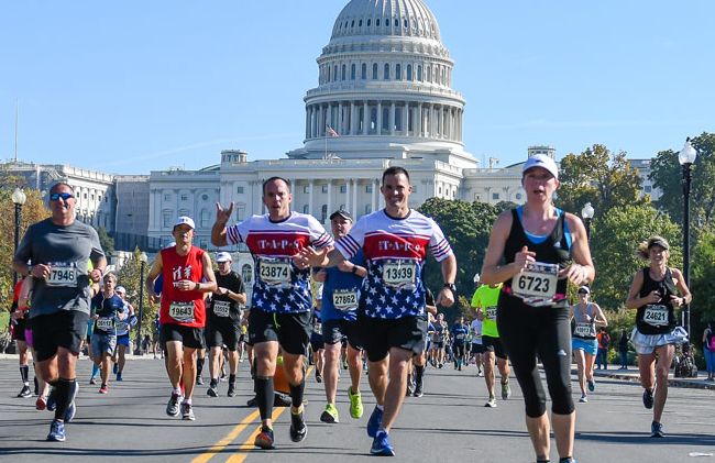
Crowd and spectators: It was truly amazing! I almost never run without my audiobook, but it was so loud and so enthusiastic that I felt that I should immerse myself in the experience and enjoy it.
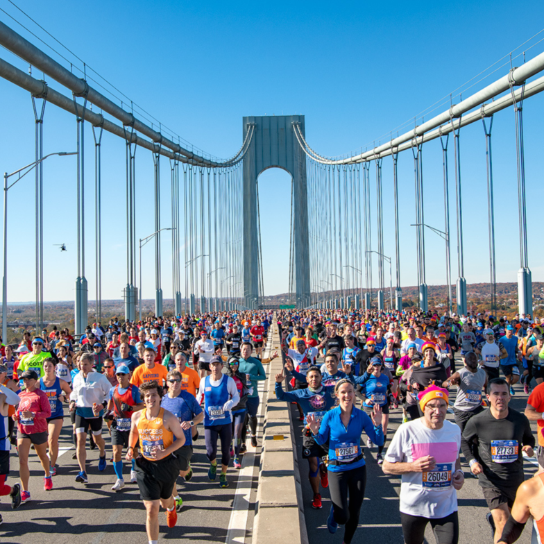
Course: It’s truly iconic as it winds through the 5 boroughs; the bridges are brutal but pretty.
Field size and growth: I’m sure there are differing opinions on this, but I’m glad they’re expanding the field. I believe this year was one of the largest ever at around 71,000 starters. At my pace, I wouldn’t ever qualify for a race like this. I’m also grateful for the second-chance lottery system that got me an entry to this race: thank you NYRR!
Start village organization: For a race with so many people, it was a good size and relatively well organized. Physical signage could have been better within the village. Audio announcements were great.
Not so much – Aspects of the race that didn’t do it for you
Not really complaints or dislikes, but things to look out for:
1. New York City Marathon course difficulty
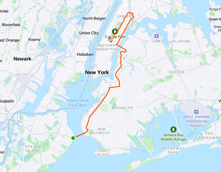
The course is brutally hard – and deceptively so. For someone from hilly Seattle, even the Verrazano Narrows and Queensboro Bridge seemed like nothing: about 150 and 110 feet elevation change about about 0.75 miles. But most of the course has rolling terrain, and if you don’t hold back or haven’t trained appropriately, you’ll destroy your calves and quads, like I did, and then fall apart at the end. For me, I was cruising through mile 19 before falling apart quite abruptly and struggling to the finish. While I would’ve been happy with my finishing time at the start of the race, given how well I was rolling and the time I was on track for before my demise, I was ultimately somewhat disappointed.
The 2025 New York City Marathon course.
2. Later starts mean warmer temperatures
Because of the expanded field, the slower runners start very late in the day. I crossed the start line about 8 minutes past by designated 11:30 am start time. Given that I had to travel east for the race, and the 2025 New York City Marathon fell on the day the clocks go back, I was happy to be able to sleep in and start the race fresh; I slept a shocking 9 hours before the race, whereas I had slept 3 restless hours before the Chicago Marathon’s 7 am start 4 years ago! However, the late start resulted in warmer temperatures and, in the end, an extremely long day.
3. Getting to the race start
The point to point nature of the New York City Marathon course, means runners must travel a long way to get to the start on Staten Island (see course map to the right). I took the ferry and then a bus on Staten Island. Other runners who took the bus all the way from Manhattan had a far longer total travel time..
Weird factor – What’s the weirdest thing about this race?
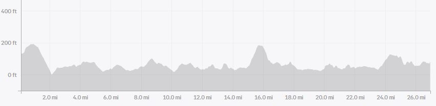
The elevation and course profile. While the Seattle marathon has about 1500 feet of elevation in a typical year, I’d argue that the 950-1000 feet of the New York City Marathon is much harder because of the rolling nature of the terrain.
Highlights of your race – What did you do well and enjoy about your race in particular?
For a glorious 19 miles, I was having an amazing time and was extremely optimistic about getting close to a PR. While the crash was rough after that, and my eventual time was disappointing, I came away with optimism that I could run considerably faster with better pacing and better planning for the course, plus some conditioning for quads, calves, and probably other muscle groups.
Even though it eventually hurt me, I felt like I did a great job of running by feel and effort… for the first 19 miles at least!
Lessons for others – Share your pro-tips on the race to help the next runner
Unfortunately, I had not seen this before the race, but in retrospect, I would research any course that I wasn’t familiar with or didn’t have a very straightforward profile, like the person in this reddit post did:
I honestly think that if I had done this sort of research myself or had found this, I would have saved about 10 minutes and not had such a bad last 7 miles.
Lessons you learned that will help you next time around
Plan for the course, and hold back if/ when appropriate.
This was my first race in running in the Nike Alphafly’s, though I had done about a 100 miles of training in them. They helped me go fast, but they had the exact problem that I was concerned they would: they substantially exacerbate any calf weakness late in the race. I think for my next marathon I’ll go with the Asics Superblast. I also liked these a lot in training, and found them much more stable and gentle, yet still fairly fast.
Most important course specific knowledge to know about the race
(Hills!! See above)
Aesthetics – Is it a pretty course?
Quite pretty. However, I don’t think I paid much attention after 15 miles or so, as I was just bearing down mentally and trying to focus.
Difficulty – Is it a tough course?
I’d say so! The constantly rolling hills really add up (see elevation map below). And if you’ve read this far, I think you already know the answer to this question!
The 2025 New York City Marathon elevation map.
Organized and well run – Did it feel like a well-oiled machine or were they flying by the seat of their pants?
Fairly well oiled, especially for a race of this size!
There were a few areas in Brooklyn where the crowd ignored the tape barriers, creating a path barely about 10 feet wide for runners to go through, which felt dangerous and badly managed in terms of crowd control.
Competition – Is there a strong field?
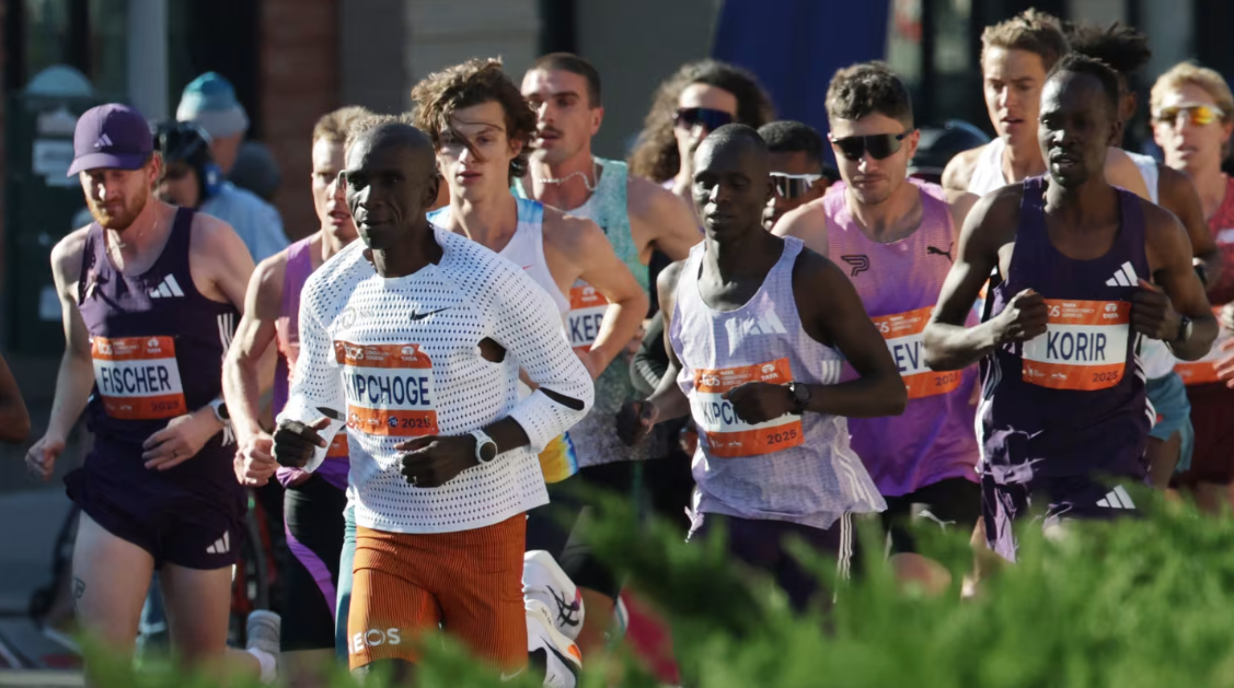
Headlined by marathon GOAT, Eliud Kipchoge, and legendary distance runner, Kenneisa Bekele, need I say more…? While Kipchoge and Bekele enjoyed their retirement tour, finishing 17th and DNF-ing respectively, the elite men’s field wasn’t short of talent. 1st and 2nd place finishers, Abdi Nageeye and Evans Chebet, returned, in a field that included 8 men who have run under 2:05:00. Americans Joe Klecker, Charles Hicks, and Hillary Bor ran their marathon debut, alongside Britain’s Patrick Dever, who ended up a second off the podium. Other notable men included: Americans Reed Fischer, Joel Reichow, and Biya Simbassa, alongside 2:02:00-marathon runners, Benson Kipruto and Deresa Geleta.
On the women’s side, the last 3 New York City Marathon finishers returned to battle it out with Olympic Champion, Sifan Hassan. Akin to the 2025 Boston Marathon, it ended up being a match race between Hellen Obiri and Sharon Lokedi, with Obiri ultimately prevailing victorious. Other notable women included: Americans Fiona O’Keefe, Molly Seidel, Stephanie Bruce, and Sara Hall, Britain’s Jessica Warner Judd, and Ireland’s Fionnuala McCormack.
2025 New York City Marathon elite men, featuring Eliud Kipchoge. PC: REUTERS/Jeenah Moon
Logistics – Does it require a special handshake, registration a year in advance, hotels all booked? Give us the low down on the nuts and bolts of making the race happen.
It’s very hard to get into the New York City Marathon! There are various different ways to enter, including qualifying standards for faster runners, charity places, and lottery picks. I got in through a second-chance lottery that randomly picks people who miss the main lottery. If you get a phone call with caller-id ‘NYRR’ pick up!
Hotels are expensive, yeah – though I don’t think it’s particularly necessary to stay in Manhattan, so you could definitely save some money by staying elsewhere.
Aid Stations – Standard fare or anything special to know about the aid stations in terms of what’s available or when?
Aid stations were pretty good: Gatorade and water every mile starting at 3, which is pretty good. They had some Maurten 100 gels available at miles 12 and 18, but I didn’t want to try something new on race day and I had plenty of fuel with me. Also, they had bananas at mile 21, which seemed odd to have just one point with them. Apparently had biofreeze was available at some of the later medical stations; in retrospect, I should have made use of that to deal with some of the discomfort in my legs.
A small complaint I have is that some aid stations couldn’t keep up with the number of runners coming through, because the volunteers seemed to be untrained and not able to keep pace. This resulted in multiple instances of runners waiting longer than ideal, and small backlogs forming. At aid stations and just after, definitely watch your step, be careful not to slip, and watch out for people crossing lanes aggressively.
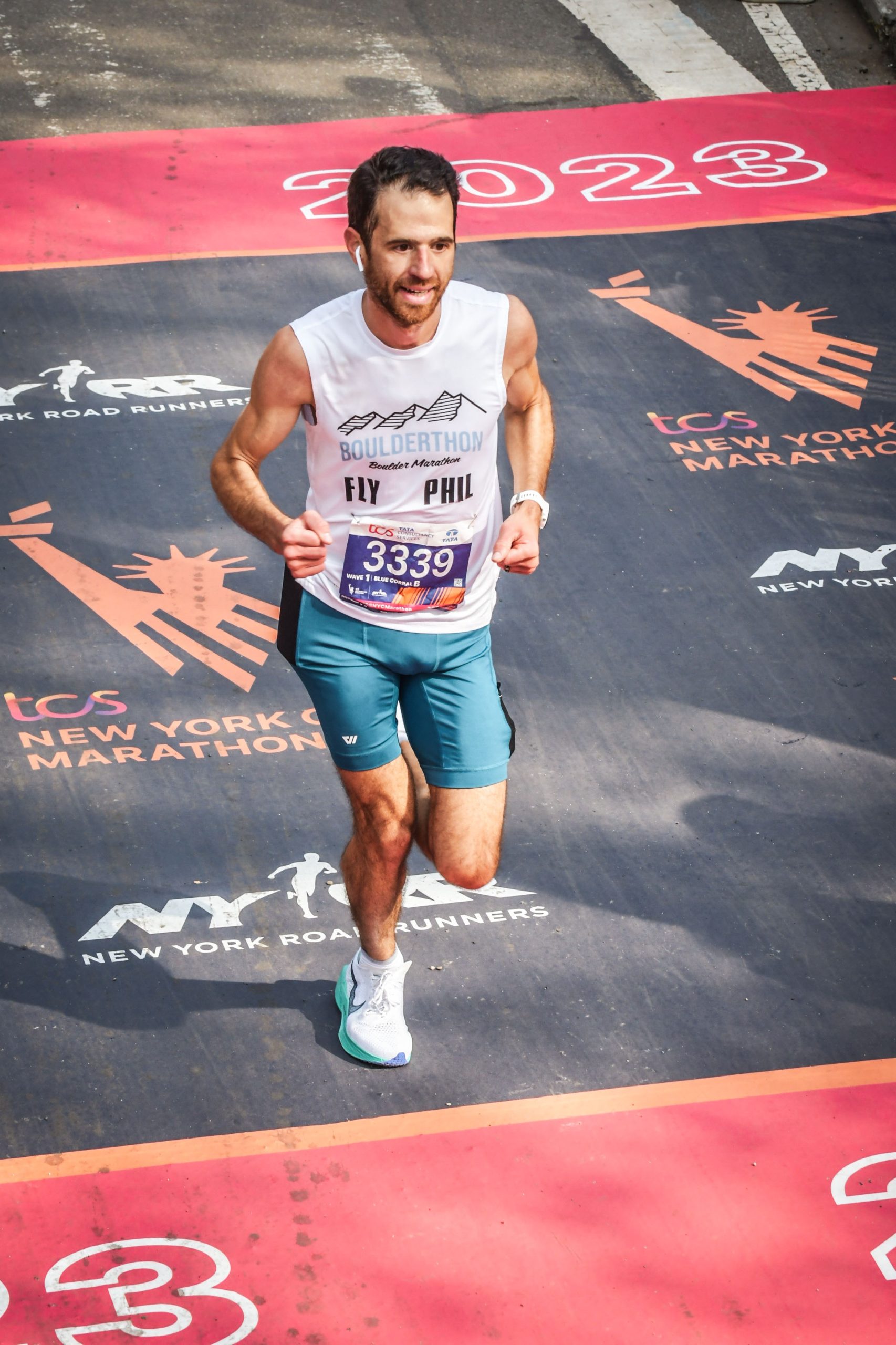
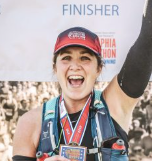
TRR athlete, Phil Shin, finishing the 2023 New York City Marathon.
Weather and typical race conditions
Typically cold and dry. Occasionally rains because it’s early November: Thursday and early Friday of this year’s race week had been extremely wet.
Gear – Did you need anything special or is there anything you’d recommend for the next runner?
I definitely would recommend a good headlamp, as it can get super dark.
Spectators – Is this a friendly course for your friends?
Yes and no. It’s a great experience as a runner, and I’d imagine as part of the cheering crowd as well. There are lots of points with great music – notably Brooklyn, Harlem, and the Bronx. However, with so many people trying to get around the city to cheer runners on at multiple points, the subway system gets pretty overwhelmed. My wife met me at 3, 8, 18, and after the finish. Even though I’m a slower runner, she just barely made it to these stops!
How’s the Swag?
The New York City Marathon 2025 t-shirt was solid, though I prefer short-sleeved shirts: thin long-sleeved shirts are just a bit of a waste for me. There’s a ton of branded apparel for sale at the expo, but I don’t typically buy that sort of thing. The medal was nice, very solid (and hard earned)!
The Overall Score – How many stars do you give this race and do you recommend that others run it?
The New York City Marathon definitely gets 5 stars! While I don’t think I would do it again for a long time, it’s an outstanding experience. I highly recommend it to others.
For more New York City Marathon insight and coaching tips, we put together this New York City Marathon 101 race guide.
3 Bests – What aspects of the race did you like the most?
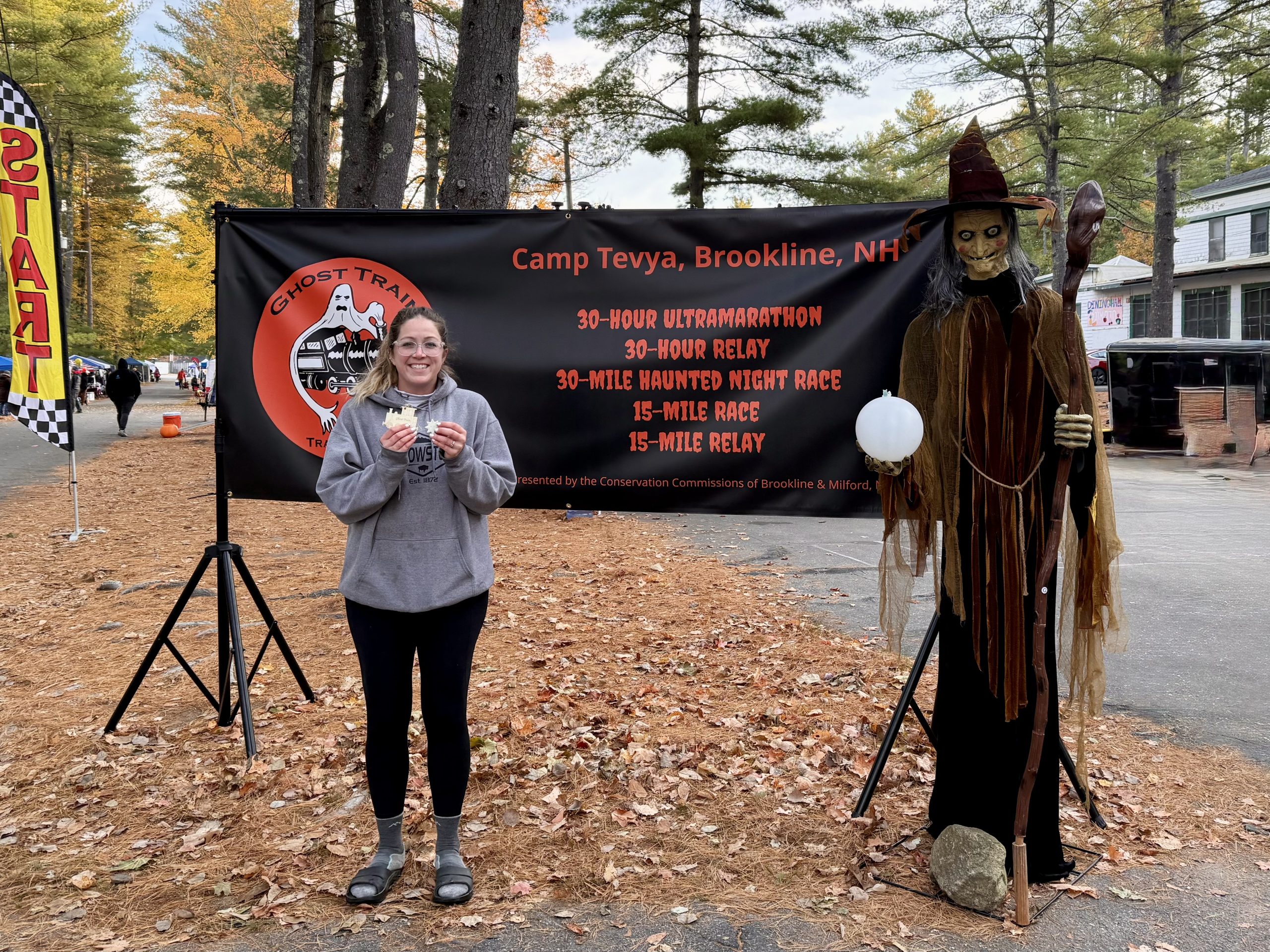
Festive: Halloween themed
Timed race: I did the 30-hour version of the Ghost Train Rail Trail Race, removing any time cut-off pressure. Given the race directors knew how long runners would be on course, alongside the looped course, aid station snacks were refreshed throughout.
Looped course: This allowed for the start/finish to be the central hub for all runners/volunteers/pacers/tents, and was easily accessible.
Not so much – Aspects of the race that didn’t do it for you
Loop length: the 15-mile laps made it difficult to make any adjustments on-course.
Night temperature: while fine for running, the low temperatures were chilly for camping overnight and anyone not running.
Weird factor – What’s the weirdest thing about this race?
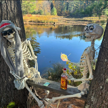
There were a lot of Ghost Train Rail Trail Race runners dressed in Halloween costumes!
Highlights of your race – What did you do well and enjoy about your race in particular?
After struggling with GI issues and blisters after the second lap (miles 15 to 30), I wasn’t sure if I would be able to continue on for a third lap at night. I did a full reset and rested for a while before heading back out. This was my first time running into the night, and handled it with no caffeine and limited calories due to my stomach issues. Overall, I’m happy I did persevere! The result: setting a new distance PR during this race!
Lessons for others – Share your pro-tips on the race to help the next runner
A few tips for runners considering this race:
October nights in New England can get VERY cold; therefore, it’s important to pack enough layers for running AND sleeping!
Even in lower temperatures, hydration is still very important to stay on top of. Don’t be fooled by the lack of sweat!
Talk to other runners. The looped course is conducive to chatting to other runners, and this makes the time go by very quickly.
Lessons you learned that will help you next time around
1. Stay on top of hydration. 2. Take care of feet early!
There’s no going back on these two things: once they start to go south, they’ll more than likely keeping going south.
Most important course specific knowledge to know about the race
1. The Ghost Train Rail Trail Race course is mostly hard-packed, rail-trail type terrain with a little bit of New England trail running mixed in. 2. The 4 mile aid station and 7 mile turnaround aid station are fully stocked with bathrooms.
Aesthetics – Is it a pretty course?
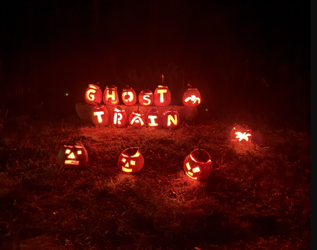
The race takes place in the fall, with some beautiful foliage and fun decorations throughout!
Difficulty – Is it a tough course?
No, it is a relatively flat and very well marked course.
Organized and well run – Did it feel like a well-oiled machine or were they flying by the seat of their pants?
Very well run! From the race director to each volunteer, everyone involved in the Ghost Train Rail Trail Race were amazing!
Competition was not the main point of focus of Ghost Train Rail Trail Races, especially in the 30-hour event. The focus is more on completion.
Logistics – Does it require a special handshake, registration a year in advance, hotels all booked? Give us the low down on the nuts and bolts of making the race happen.
Registration was VERY competitive. For example, the 30-hour Ghost Train Rail Trail Race sold out in about 2 minutes! Fortunately, there are several different Ghost Train Rail Trail Race distance options.
Aid Stations – Standard fare or anything special to know about the aid stations in terms of what’s available or when?
Aid stations had plenty of snacks and sodas, with Tailwind as the endurance fuel option. The halfway aid station had a lot of homemade goodies and plenty of hot food!
Halloween-themed fun along the Ghost Train Rail Trail Race course.
Weather and typical race conditions
The Ghost Train Rail Trail Race happens during fall in New England, so can vary drastically. This year, it got quite cold during the night. Be prepared for everything, especially the worst!
Gear – Did you need anything special or is there anything you’d recommend for the next runner?
I definitely would recommend a good headlamp, as it can get super dark.
Spectators – Is this a friendly course for your friends?
Friends are able to hang out at the start/finish area, and pacers are allowed during the night portion.
How’s the Swag?
There is a wooden train ornament for finishers, as well as a PR star.
The Overall Score – How many stars do you give this race and do you recommend that others run it?
I would DEFINITELY recommend any of the Ghost Train Rail Trail Race events to others!!! It’s festive and fun, great weather (at least in 2025 there was!), a lot of aid station food and bathrooms, and very well run. Above all, it’s a great format to go for distance PR’s and to chat with other runners.
Allie Smith is a coach with Team RunRun based in Gloucester, MA. She enjoys helping the everyday athlete have fun, build confidence, and fall in love with running!
Known for being one of the fastest marathons in the country with it’s net downhill elevation profile, the California International Marathon (CIM) is a top choice for those chasing Boston Marathon and U.S. Olympic Trials Marathon qualifiers.
Look out for TRR Coach CJ Albertson as he ticks off his 6th marathon of the year (!!) on his hometown course. Of the last 5 CIM’s, CJ’s run 4 of them, including winning the race in 2023 and two runner-up finishes!
1. Pre-Race Zoom Call
With the California International Marathon (CIM) coming up soon, we’re bringing veterans and first-timers together to ask questions, share insights and build some excitement heading into race weekend!
I highly recommend turning off autolap and using the manual split button on your watch and course markings to gauge your pacing. If you decide to use auto lap, subtract 2-3 seconds per mile from the splits listed below to account for gps and tangent error.
Start off conservatively! The first mile is a downhill effort. The race day vibes are contagious, and it is easy to get sucked into the race atmosphere! Go in with a gameplan, and stick to it!
0-6 miles. The first 5-6 miles are pretty aggressive downhill, there are still a couple rolling hills but losing a lot of elevation. Start the race running conservative mile splits. CIM is a course i recommend focusing on 3 mile splits and not each individual mile, especially in the first 13.1
Although the course is net downhill, there are some gentle rollers on the course. Make sure to check your effort +/- 5 seconds per mile depending on the part of the course.
6-12 miles. Rolling portion of the course. In general, I’d recommend letting the miles slip by around 5 seconds a mile here through here while maintaining a similar effort while you were running the first 6 milers. Only thing to note here, rolling hills stop at 10 and the downhill picks back up. Splits will likely pick back up naturally from 10-12. If they do, aim to hit what you hit for those first 6 miles.
12-18. Resumes the downhills. The section is much more even than not, it’s just a very smooth downhill.
We are getting to the point where we want to start consciously progressing forward. You should begin making an intentional push forward. I Don’t make any big risks yet, but get yourself into a settled rhythm, pacing and effort. After 16, you should be able to gauge your effort, feel out where you are at in the race.
Once you are at 18 miles, its all about cranking to the finish line. Gauge your effort, settle into goal pacing, and head home!
“They say CIM is net downhill. What they don’t tell you is that the first 10 miles are rolling hills. Train hills and you won’t notice them. Don’t train hills and listen to the hype about a “downhill race” and you will be very surprised at your finish time… and not in a good way.” – Coach Jamie Spruiell
California International Marathon (CIM) course and elevation maps.
3. Race Reports
Want even more intel on the California International Marathon (CIM)? Read some of the race reports from Team RunRun coaches:
At Team RunRun, we have 100s of wonderful, experienced coaches ready to help you crush your goals, regardless of your ability, budget, or lifestyle. Specifically, for CIM race advice, here are some coaches to start with:
3 Bests – What aspects of the race did you like the most?
Terrain and scenery: If you have not spent much time in the western part of Michigan’s Upper Peninsula, it should definitely be on the top of your vacation / race list. The colors were about to turn, and mother nature provided great weather. This race is timed to coincide with peak fall colors!
Crewed by my wife: This was the first race my wife crewed for me. Typically, I run my races with support from drop bags and aid stations, but this time, my wife was there to crew me the entire race. I enjoyed sharing the experience with her.
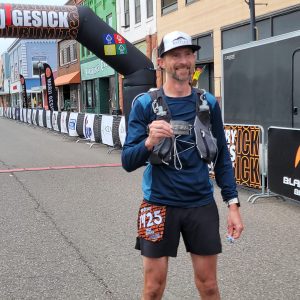
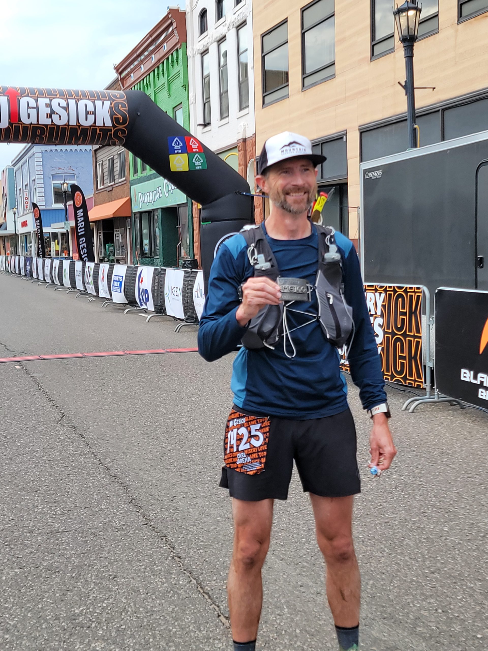
Community: The Marji Gesick 100 is self- / community-supported race, and it was fun and exciting to interact with all the other runner crews. They always offered water, food, or any assistance, really highlighting one of the aspects that makes trail and ultra such a special community.
Not so much – Aspects of the race that didn’t do it for you
There really is not too much I don’t like or love about this race. The mountain bike race, which starts 24 hours after the run, is on the same trails, so depending on your pace and time, you may need to step aside or navigate the bikers as they pass. It is not all bad though. Based on my 2023 experience, every bike rider cheered and encouraged me along the route. The inconvenience of stepping off the trail was balanced out by the support from the bikes.
Weird factor – What’s the weirdest thing about this race?
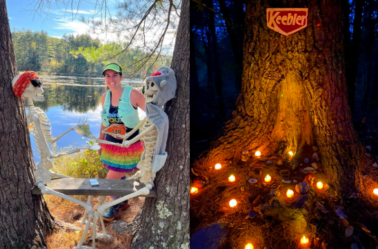
Everything about this race is weird and unconventional! Marji Gesick really is a 365 day event. Registration sells out in minutes, there is not waitlist, and the intentional misinformation, confusion, and tom foolery from the race organizers and fellow participants is nonstop to race day. Check out “Marji Geski Talks” on Facebook, and you will understand. The 100 mile run starts with a 0.5 to 0.75 mile bike ride. Yes, you need to bring a bike to a running race! There are no aid stations. You bring your own crew, or you rely on the community. Full stop. It is up to you to prepare. The course map is available only a couple days before the race, and to prove you ran all 100 miles, you need to collect “tokens” from plastic pumpkin buckets along the course. The tokens could be “Dum Dum” suckers, random objects, or wooden tokens. Trust me, if something is in a bucket, you need to bring it to the finish line. This year, I collected 2 suckers and 3 wooden tokens. Oh, and just for fun, there are even more “fake” buckets that are completely empty!
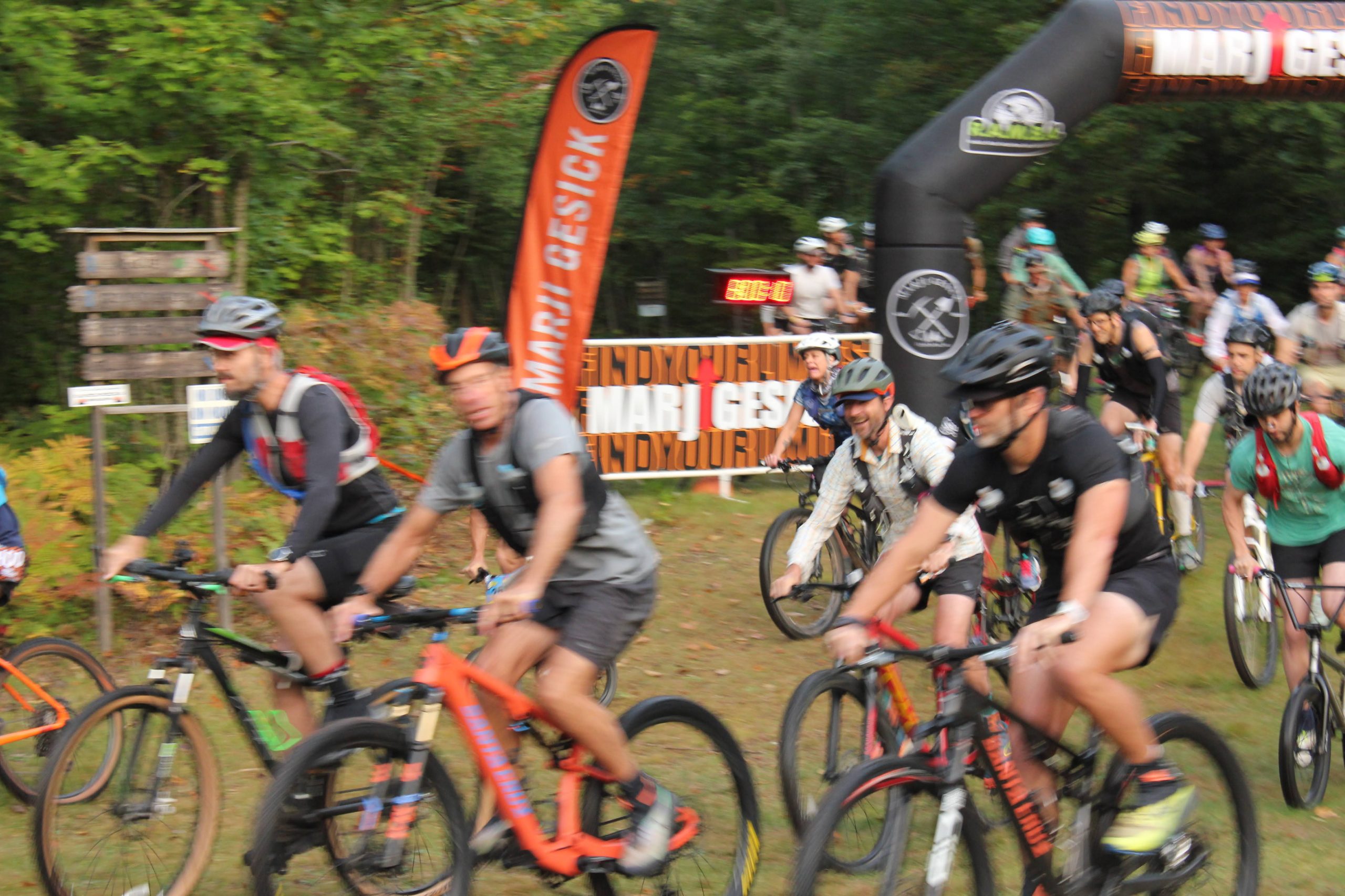
The mountain bike start to the Marji Gesick 100 Mile, an ultramarathon running race!
Highlights of your race – What did you do well and enjoy about your race in particular?
This race for me was what the Marji community calls #unfinishedbusiness. I completed the Marji Gesick 100 in 2023 in a little over 39 hours. Yes, it was my first 100 mile race, but I knew I had much more potential. My training was less than I wanted, I didn’t know how to fuel, and I was only a couple years into my running rebirth. Add to that, I slept terribly the week and days before (my dad was suffering from cancer at the time, and I got a call around mile 40 that he fell unconscious and wouldn’t wake up. He passed away less that 2 days after I finished).
OK, sorry for the bummer start. But, this time, I was able to train very well heading into the race, and my nutrition and hydration were dialed. I ran way more of this race than I have in other 100 milers, and I finished in time to earn my belt buckle, awarded to runners under 28 hours.
Lessons for others – Share your pro-tips on the race to help the next runner
A few tips for runners considering this race:
Do your homework. There is no race packet or step by step instructions for the race. You need to go out and dig up the information. It is worth getting onto the Marji Gesick Facebook pages, and yes, if you do not have a Facebook account, it might be worth creating one.
Plan your crew. This is pretty much the same for every race that allows crew, but remember, there are no aid stations to fall back on. Coming up with a detailed crew plan is a must.
Be ready for sudden changes in weather. The race happens on the shore of Lake Superior, it can go from 70 and sunny to 40 and rain in minutes.
Positive split pacing. Last, the back half of the race is more technical and harder to run. I recommend banking some time in the first 60 miles, if possible, but don’t over do it.
Lessons you learned that will help you next time around
I think I would add more crew stops. We planned on about every 10 miles, and during the afternoon, I was running out of water between stops and had to slow down a bit. I noticed runners with more stops were moving a bit better and faster during the warmer part of the day. I also would try to limit my stop time a little more. We had a hard cap of 10 minutes max at any stop. I think in the future I would try to limit that to 5 minutes. Also, a waist light is a must. I did have a waist light, but I didn’t plan a better way to attach it to my belt. I could have moved better at night if I had better lighting.
Most important course specific knowledge to know about the race
Make sure you are keeping your head up and don’t miss the pumpkins! Don’t worry, they are not hidden like the books in the Barkley Marathons, but as the race goes on, you could miss one in a sleep deprived state. Also, be ready for the punchy and rocky climbs that come after mile 60. The first half of the race has pretty good flow to it, however, after mile 60, there are a lot of technical trails with short, but very punchy climbs. Don’t forget, the race will probably be somewhere between 100 and 110 miles, so don’t get discouraged when you cross 100 miles on your watch and there is still and hour or two left to go in the race.
Aesthetics – Is it a pretty course?
The race is beautiful. You spend most of the time running through the forest just as the leaves start to change. You are treated to views of lakes, and you run along rivers: there are few better places to suffer.
Difficulty – Is it a tough course?
The course is harder than the elevation profile will show. The course is much more like an east coast trail: rocks, roots, and punchy climbs. No climb is terribly long, but they just keep coming. Be ready for a tough go at the end of race. This years Marji Gesick 100 race was closer to 110 miles with over 13,000 feet of elevation!
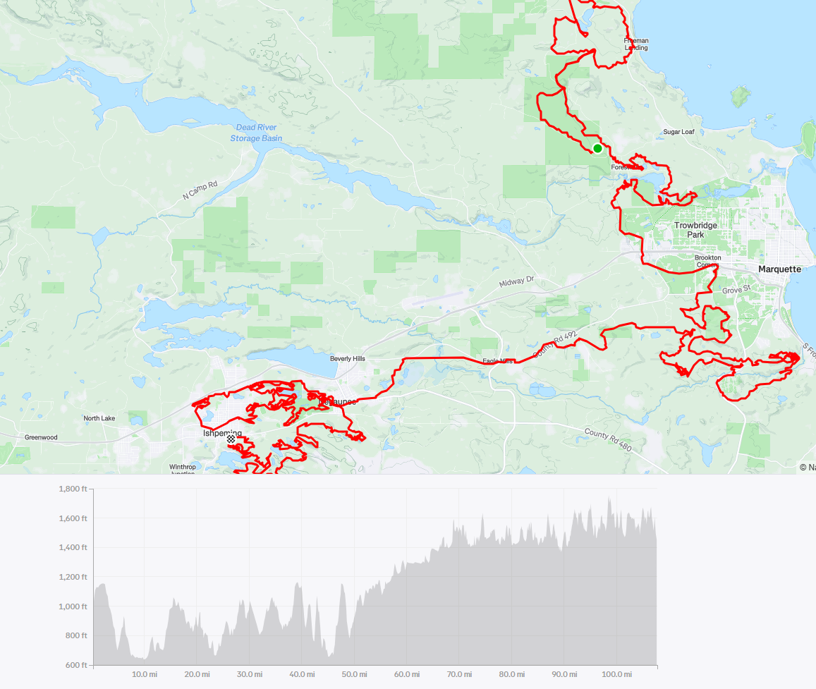
Marji Gesick 100 Mile course map and elevation profile.
Organized and well run – Did it feel like a well-oiled machine or were they flying by the seat of their pants?
Despite it’s unconventional nature, the Marji Gesick 100 is very well run. Remember, this is intentionally difficult to get information, but the race itself is run very well and smoothly. The after party is work sticking around for, cheering on the other race distances between the runners and bikers.
Competition – Is there a strong field?
This year had one of the stronger fields. There were a record number of runners and bikers earning buckles, finishing under 28 and 12 hours respectively. 2025 also saw the first 3 women earn buckles for mountain biking! The biking field is very strong, with a number of sponsored riders, but the run is more regionally competitive.
Logistics – Does it require a special handshake, registration a year in advance, hotels all booked? Give us the low down on the nuts and bolts of making the race happen.
The registration for the run is on BikeReg, which might seem odd. Also, there is no waitlist, and the race sells out in less than a minute for the bike races and within five minutes for the runs. Even though there is no waitlist, if you stay connected to the Facebook pages you likely will be able to find a bib transfer or win a random race entry for playing along with the random games.
Aid Stations – Standard fare or anything special to know about the aid stations in terms of what’s available or when?
There are NO AID STATIONS! On Saturday afternoon, the community does come out and create some aid stations, but those are often not there during the run. However, as the run has gained popularity, each year sees more community members coming out to set up aid for the runners. Make sure you come with a well planned out crew support plan.
Weather and typical race conditions
This is early fall in Michigan’s UP. Every year the weather has been different, from 80 degrees and sun, to 40 degrees and rain. This year, the temperature was in mid 60s to low 70s, with sun during the day for the run. Saturday afternoon and evening, rainstorms came in and soaked many runners and bikers still on course. Make sure you crew has clothes for you for all weather.
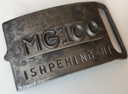
Marji Gesick 100 Mile belt buckle.
Gear – Did you need anything special or is there anything you’d recommend for the next runner?
I did not bring anything special. The Marji Gesick 100 is not a mountain race, but I did find my poles to be helpful. Also, a secure waist light is a game changer on the technical trails.
Spectators – Is this a friendly course for your friends?
Because it is crew supported, friends and family can see their runner very often during the race. There are very few limitations to where crew and spectators can access. Only rule – no pacers!
How’s the Swag?
This is a non profit organization, so all race swag is for purchase only. Personally, I like this idea. I have too many shirts, medals, and other race swag just collecting dust and it feels wasteful. I do not mind deferring any additional cost from registration to “free” swag vs purchasing on my own. Also, you do get to keep your tokens as an award. Note that this is also a buckle or bust race: if you don’t buckle (finish under 28 hours), there is no finisher medal.
The Overall Score – How many stars do you give this race and do you recommend that others run it?
9 out of 10 starts. This is a 365 day event, and the community is awesome. Once the community comes out to the run like they do for the bike, I will rate the Marji Gesick 100 10 out of 10 stars!
3 Bests – What aspects of the race did you like the most?
Autumn: This race is timed to coincide with peak fall colors!
State-to-state traverse: It’s pretty unique for a 100-mile course to take runners across state borders.
Porcupine sighting: During the night, a porcupine ran in front of me on the trail for a few seconds before moving off to the side. And no, I was not hallucinating!
Not so much – Aspects of the race that didn’t do it for you
I can’t think of anything. I suppose it would have been nice to have some more cloud cover midday, but that’s not something the RDs can control!
Weird factor – What’s the weirdest thing about this race?
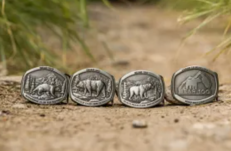
Nothing weird. A unique factor is different buckles for various finish times: –Black Bear Buckle: 30-36 hours –Grizzly Bear Buckle: 24-30 hours –Wolverine Buckle: under 24 hours
Highlights of your race – What did you do well and enjoy about your race in particular?
Pre-race mindset and expectations
My only goal for the Bear 100 Endurance Run was to focus only on the process of running 100 miles. This would be an internal journey to rediscover my “why”, which had become blurred. After almost two years of non-stop competing and tune up performance-based events, I wanted to go back to my roots and simply endure. I needed the Bear 100 to purely be about working with the terrain to get from Utah to Idaho. I wasn’t completely certain what focusing only on “the process” would look like in action when I toed the line, but I felt confident the best methodology would reveal itself.
Once we began the first climb, it didn’t take long for me to realize that I was carrying a massive amount of cumulative physical fatigue from racing Hardrock 100 earlier this summer. I also identified that I did not have the mental capacity yet to go back into the pain cave and embrace suffering like I did during the second day of Hardrock 100. My approach became clear in that moment: I would run the Bear 100 at a chill and causal pace. My goal was to be intentional, but not urgent. It didn’t matter how long it took me or where I placed.
Day 1
I was surprised at how easy it was for me to commit to this plan. I never once felt compelled to reel runners in or calculate a finish time based on my pace. Shockingly, I probably only checked the clock three times during the entire 31-hour event! Instead, I focused on moving efficiently through the course and proactive self-care.
During early portions of the first day, I pushed a bit harder uphill, drawing from my Hardrock training. Then I chilled on downhills to preserve my quads. Carbohydrates, electrolytes, and fluids were consumed regularly, and I maintained steady energy. By afternoon, the sun exposure became powerful in short sections and my focus switched to active cooling. I backed off on my intensity through these portions, stopping at creeks to throw water on myself whenever possible.
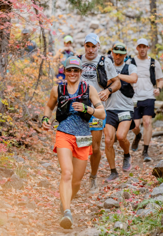
Dandelion running through fall foliage during the Bear 100. PC: Bethany Draper
Moving into the evening, I upped my consumption of solid hot foods at aid stations. I wasn’t going to be blasting through the climbs ahead and knew the reduced bouncing made GI distress unlikely. Hot foods (and drinks) would help me maintain a warm core, which would be essential to get through the night. The early hours of darkness were warm, so I stayed with light layers to reduce sweat; any moisture build up would cause me to freeze later. Later, when the temperature plummeted in the basins, every layer went on, plus hand warmers.
Running into the night
While I was never warm throughout the night, I wasn’t cold either. I stopped a bit longer at two aid stations to reset my internal temperature near the fire. I never got too close though, as I didn’t want to get overly warm and have the sudden cold suck the life out of me when I went back onto the trail! The miles clicked by as the long night wore on and I kept moving forward.
Warmth did not return upon sunrise. I continued eating hot food as I moved in and out of aid stations. I didn’t rush, but I also never lingered at aid stations throughout the event. After the final aid station at mile 91.8, I climbed the final hill. This is a notorious climb in the race because, although short, it’s mercilessly steep. I remember feeling indifferent about it, falling naturally into the mountaineer’s rest step. Unhurried, but efficient.
Day 2 to the finish
At the top of the ascent, it was finally warm enough to remove what remained of my nighttime layers. By no means did my body feel fresh! It was apparent that I had done something significant. Transitioning from hiking to running was bit awkward, but after a minute my body would adjust to the gait. Reading rocky terrain took a bit more mental effort, but I wasn’t tripping. My quads were sensitive, but not blown, so I could still maintain a gentle trot downhill. All things considered, physically and mentally, everything was still functioning well and my energy remained even. It stayed that way until I crossed the finish line in the afternoon on the shore of Bear Lake.
It sounds ridiculous to say that I ran a very casual and chill 100 miles, but that is honestly the best way I can describe this race. I truly stuck to my plan of running 100 miles for the sake of running 100 miles. I would not describe the experience as easy, but I cannot identify a moment of struggle either. The process felt familiar and intuitive to me. For the first time in a while I didn’t feel plagued by imposter syndrome. The Bear reminded me that I know how to run long distances through the mountains. Did I drain the tank? Absolutely not… but that wasn’t the point of completing The Bear 100. I was searching for something more internal.
Lessons for others – Share your pro-tips on the race to help the next runner
Cattle on the course! This is standard issue on many trails in the “Square States”, but folks less familiar may find loose livestock intimidating. There is no need to be afraid, and the bovines will move off the trail with gentle encouragement. Living in the ‘cowboy state’, I meet cattle all summer on training runs and have never had a negative encounter.
Lessons you learned that will help you next time around
My biggest lesson was very internal. Not every event needs to be a competition or even have a performance goal. So much joy can be found by simply running the course with no plan beyond being efficient and proactive with the process while appreciating the journey. Executing an event in this style helped me to reset my mental state so I can take on the challenge of competition again next season.
Most important course specific knowledge to know about the race
The Bear takes place during “Indian Summer.” This is the time of year in the Rockies where temperatures can swing wildly. Heat exhaustion can be a real danger during the day, while at night hypothermia can become a reality. Prepare with gear to avoid both dangers.
Many of the earlier aid stations are 8-10 miles apart, which is long for most 100 milers. It’s not problematic, but nutrition and hydration need to be planned accordingly.
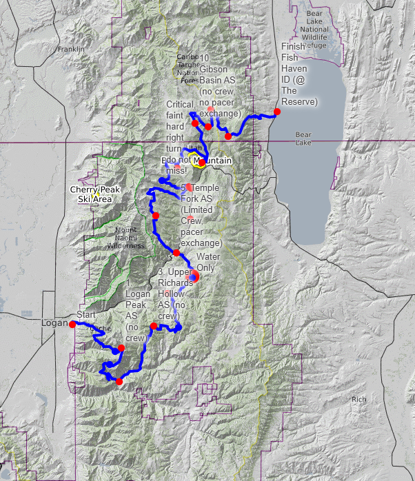
The Bear 100 course map.
Aesthetics – Is it a pretty course?
Yes! Think red maples, yellow aspens, golden grasses. The Bear 100 is timed when fall colors are peaking, and the sweeping mountain vistas are a ablaze with an autumn palette. It is a spectacular course!
Difficulty – Is it a tough course?
The Bear 100 is a proper Hardrock 100 qualifier. It has about 22,000 feet of vert in a mountainous environment, and covers a good amount of technical rocky terrain. However, many of the climbs are not aggressive (simply long), so a great deal of the course can be run if the athlete desires.
Organized and well run – Did it feel like a well-oiled machine or were they flying by the seat of their pants?
Cody and Bethany Draper are excellent RDs and have everything dialed. If anything went wrong during the event, I never found out about it.
Competition – Is there a strong field?
Yes! Elite athletes show up to this event regularly, and stellar times were put up this season on both the male and female podiums.
Logistics – Does it require a special handshake, registration a year in advance, hotels all booked? Give us the low down on the nuts and bolts of making the race happen.
This year (2025) was the final year The Bear 100 was available for first come first served registration. Moving forward it will be a lottery due to huge demand (it filled in about 8 minutes after opening in 2025!). Runners can also gain entry by acquiring a Bear Tag through winning a partner race. Further details can be found at https://bear100.com/lottery/.
Aid Stations – Standard fare or anything special to know about the aid stations in terms of what’s available or when?
The aid stations featured traditional fare: chips, soda, goldfish, broth, granola bars, quesadillas, trail mix, pickles, PB&J, etc. Gnarly and Gu sponsored the event, so their products were offered as the main engineered tech nutrition option. Later aid stations offered some special options like pizza, French toast sticks, hashbrowns, eggs, soup, tater tots, avocado sandwiches and perogies; a nice, wide range of options!
Weather and typical race conditions
Late September in the Rockies can be fickle. As was the case in 2025, this race usually has “Indian Summer” mild conditions: warm temperatures during the day, and colder nights. However, there have also been years with extremely hot daytime temperatures and bitterly frigid nights. Snow is also possible. In fact, the week after the 2024 edition it snowed a few inches on the course. Rain and electric storms are also possible. In general, anything and everything can happen this time of year in the mountains, so be prepared!
Gear – Did you need anything special or is there anything you’d recommend for the next runner?
I brought my standard mountain 100-mile race kit. My biggest recommendation is to be ready for a cold night. It drops into the 20s or 30s (degrees Fahrenheit) most years. During the day, I only carried a very light jacket. Leading into evening, I picked up an alpha fleece, hard-shell jacket, gloves, buff, long sleeved shirt, and hand warmers from a drop bag. I used every single item. The layers made the temperature tolerable while I was in motion, but I would not say I felt toasty warm.
The different buckles on offer for finishing the Bear 100 based on finish time.
Spectators – Is this a friendly course for your friends?
As I did not have crew, I cannot comment much on the logistics of getting to aid stations. However, Right Hand Fork and Temple Fork aid stations have limited space, so runners must pick between one of the two locations to meet their crew at (a pass is provided). The start is certainly easy for speculators to get to as it is in the city of Logan, Utah. The finish line in Fish Haven, Idaho, is on the beach of Bear Lake: a beautiful set up for folks to hang out all day and enjoy watching runners complete their journey.
How’s the Swag?
The Bear 100 had plenty of pleasantly affordable swag available to buy at the pre-race check in. Additionally, all athletes received a shirt and socks in a nice tote bag. Finishers were awarded with a unique buckle and wood plaque.
The Overall Score – How many stars do you give this race and do you recommend that others run it?
10/10. If you love a classic Rocky Mountain ultra set against the colorful tones of autumn, do this event!
Dandelion Dilluvio-Scott is a multisport outdoor athlete, ultra-runner and certified coach. She is passionate about collaborating with driven athletes who love to explore, train and play outside.
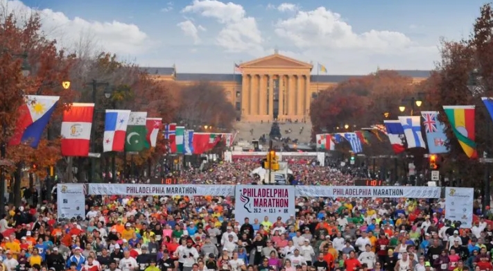
Often overlooked in favor of the World Marathon Majors, the Philadelphia (Philly) Marathon is one of the most popular in the United States, for good reason!
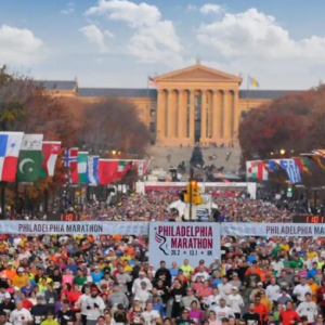
Philadelphia Marathon race start.
1. Pre-Race Zoom Call
With the Philadelphia Marathon coming up soon, we’re bringing veterans and first-timers together to ask questions, share insights and build some excitement heading into race weekend!
Join our drop-in Zoom call on Monday, Nov. 10, 2025 at 7:00 pm EST where first-time Philly runners can get answers from athletes and coaches who have run this race before.
If you think you can make it, or want to submit a question in advance, email your host TRR coach Elaina Raponi at [email protected].
Can’t make the call? We’ll record the call and share the link in the following week’s newsletter.
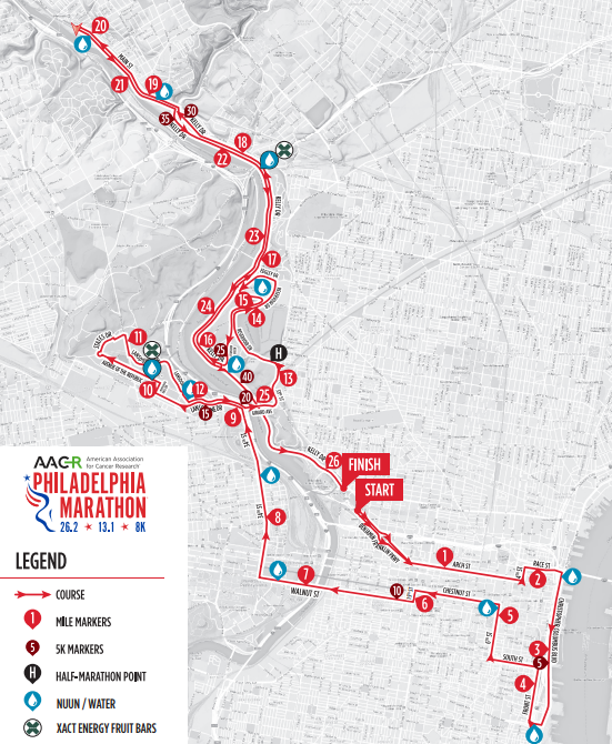
2. Philadelphia Marathon Race Intel
Date: Sunday, November 23, 2025
Philadelphia Marathon course map.
Location: Philadelphia, Pennsylvania
Start: 22nd Street & Benjamin Franklin Parkway, near the Philadelphia Museum of Art
Finish: Eakins Oval on Kelly Drive, near the Philadelphia Museum of Art
Course type: Mostly a loop; take a look at this page for more Philadelphia Marathon course info
Boston Qualifier: Yes
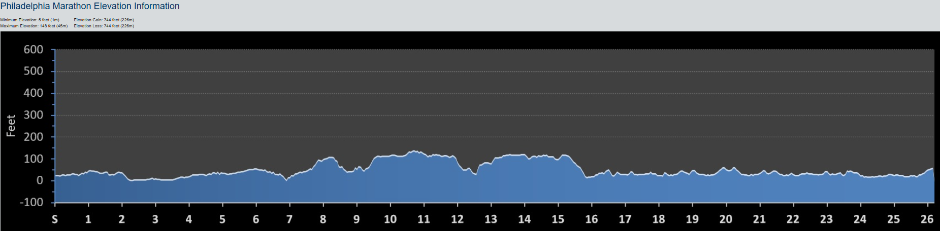
Elevation gain: 744 feet/ 226 meters
Elevation loss: 744 feet/ 226 meters
Temperature:
Average high: 51°F/ 10°C Average low: 34° F/ 1°C
Tips from Coaches
“Practice hills! Philly is not classified as hilly, but the rolling hills from miles 7–16 and the tougher climbs in Manayunk (miles 19–22) add up.” – Coach Jonathan Gooch
“Stick to the tangents. Kelly Drive is wide and winding, and poor tangents can add up to half a mile to your race, so minimize side-to-side movement to stay on the shortest course.” – Coach Jonathan Gooch
“The race ends with a 10 mile out-and-back on the river that feels longer than the first 16; save some mental energy to get back from the turn around.” – Coach Matt Weller
Philadelphia Marathon elevation map. PC: findmymarathon.com
3. Shakeout Run
Date: TBD
Time: TBD
Location: TBD
4. Philadelphia Marathon Coaching Info
At Team RunRun, we have 100s of wonderful, experienced coaches ready to help you crush your goals, regardless of your ability, budget, or lifestyle. Specifically, for Philadelphia Marathon race advice, here are some coaches to start with:
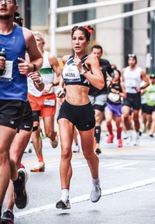
TRR Coach Natalie Lutz running the 2023 Indy Marathon.
Often overlooked in favor of the World Marathon Majors, the Indianapolis (Indy) Monumental Marathon is a flat, fast race perfect for PR-seekers and first-timers.
1. Pre-Race Zoom Call
With the Indianapolis Monumental Marathon coming up soon, we’re bringing veterans and first-timers together to ask questions, share insights and build some excitement heading into race weekend!
Join our drop-in Zoom call on Monday, Oct. 27, 2025 at 7:00 pm EST where first-time Indy runners can get answers from athletes and coaches who have run this race before.
If you think you can make it, or want to submit a question in advance, email your host TRR coach Elaina Raponi at [email protected].
Can’t make the call? We’ll record the call and share the link in the following week’s newsletter.
2. Indianapolis Monumental Marathon Race Intel
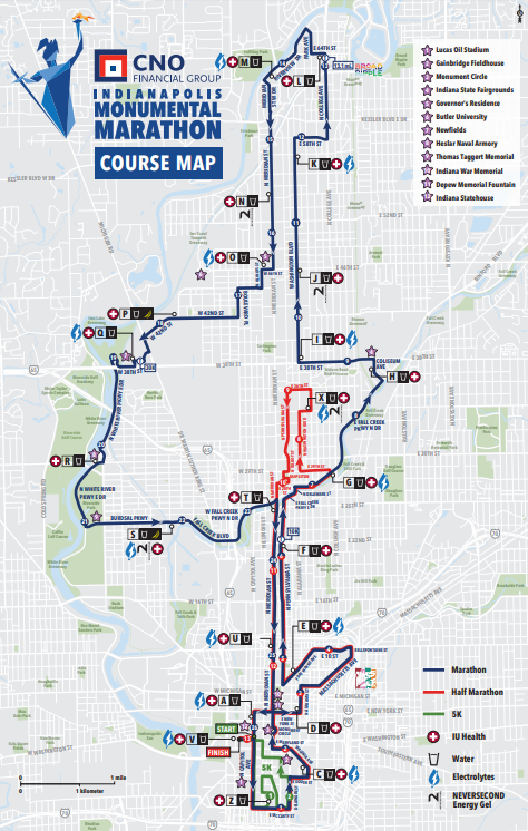
Indianapolis Monumental Marathon course map.
Date: Saturday, November 8, 2025
Location: Indianapolis, Indiana
Start: Near the Indiana State House
Finish: Near the Indiana State House
Course type: Loop; take a look at this page for more course info
Boston Qualifier: Yes
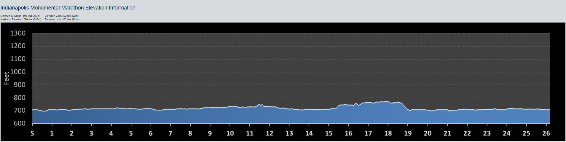
Elevation gain: 302 feet/ 92 meters
Elevation loss: 302 feet/ 92 meters
Temperature:
Average high: 58°F/ 14°C Average low: 39° F/ 3°C
Tips from Coaches
“The half marathon and marathon start at the same time. So, especially if you are in the top corrals, be aware that the race goes out very fast. Try not to get caught up and pulled along with the half marathoners in the beginning. Run your own race and pace to avoid hitting the wall too early!” – Natalie Lutz
“Be extra vigilant of your footing and the road bifurcations during the first 3 miles. In 2024, there were a few pot holes in the beginning of the race.” – Natalie Lutz
3. Race Reports
Want even more intel on the Indy Marathon? Read some of the race reports from Team RunRun coaches:
Indianapolis Monumental Marathon elevation map. PC: findmymarathon.com
4. Shakeout Run
Date: TBD
Time: TBD
Location: TBD
5. Indianapolis Monumental Marathon Coaching Info
At Team RunRun, we have 100s of wonderful, experienced coaches ready to help you crush your goals, regardless of your ability, budget, or lifestyle. Specifically, for Indianapolis Monumental Marathon race advice, here are some coaches to start with:
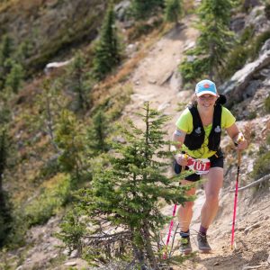
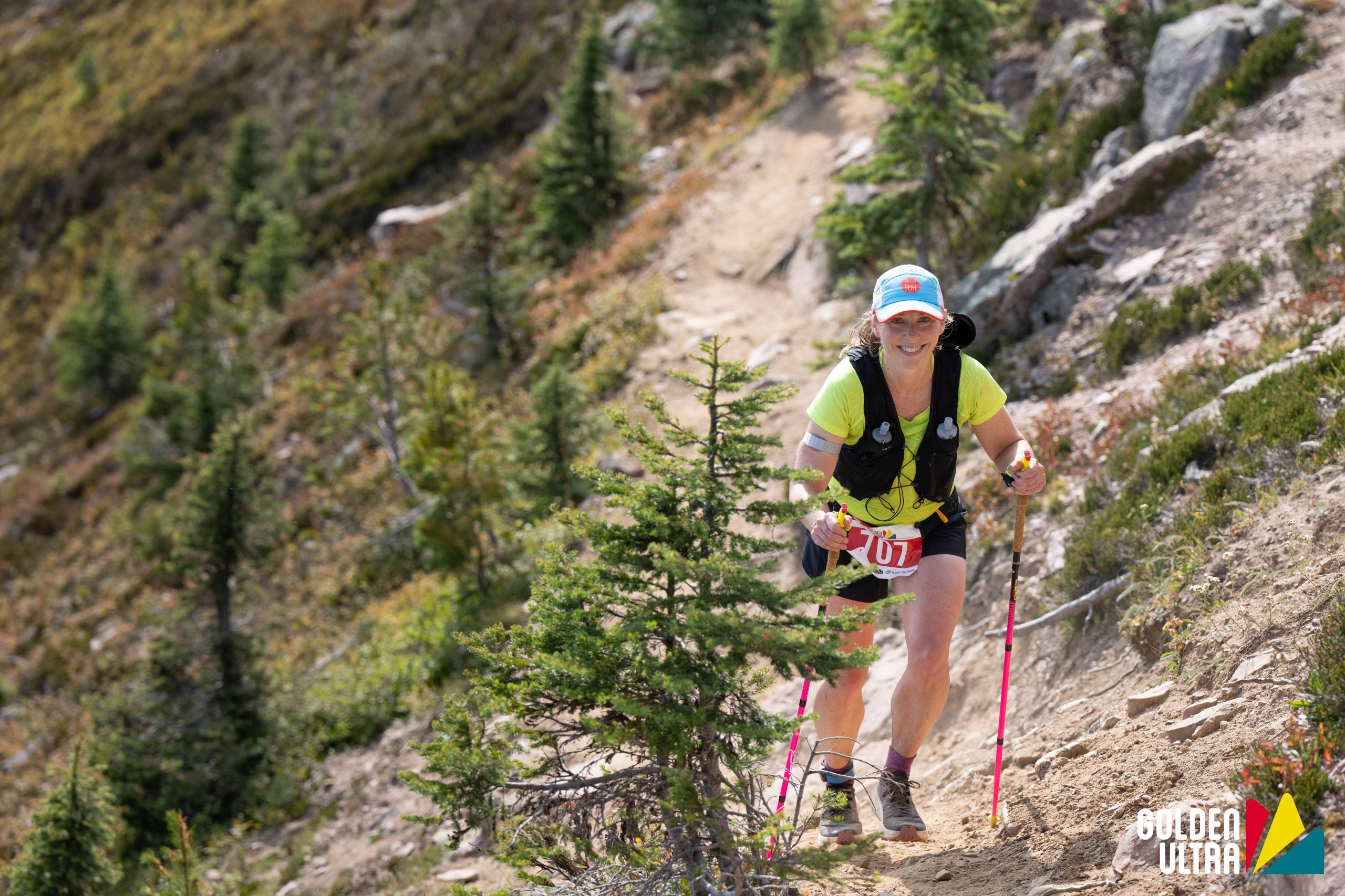
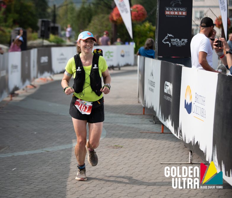
TRR Coach Jennifer Kozak running the Golden Ultra 60K race. PC: Jonathan McLeod
3 Bests – What aspects of the race did you like the most?
The Golden Ultra is a three-day stage race or a one-day ultra running race in Golden, BC, Canada. I chose the one-day, 60K ultra option.
1. Volunteers/Aid stations: This was by far the highlight of the race for me! The aid station volunteers went so above and beyond, it felt like I had crew! I would arrive, and immediately one person was helping me find my drop bag, while two other people were filling my bottles, and a fourth was holding my poles. They put ice in my hat, dumped water down my back, offered me tater tots, bacon, and quesadillas, all while telling me how good I looked, ha! As we approached the summit for the day, we were greeted with a team of dancing men dressed as fairies encouraging us up to the top. All of these amazing people meant I had a smile on my face for most of the day.
2. Flagging: The course was very well marked for the day. The few instances where I was worried that I had taken a wrong turn, I simply had to wait one minute, and the next flag would appear. Any turn was either manned or flagged so well that you knew exactly where to go. Despite some hesitancy that I missed something when I ultimately would zone out for a while, not a single turn was missed.
3. Course: The mountainous course is beautiful and challenging, and you get a little bit of everything: flowy single track through the forest, a technical, steep ridge climb to the top of the Kicking Horse Mountain Resort Gondola, and some quad busting descents.
Not so much – Aspects of the race that didn’t do it for you
1. Timing: From a participant perspective, it seemed like something went awry with the timing. When crossing the finish line, the zone4.ca updated your time automatically based on the chip you are wearing. Then, later in the day, all of the times had between 45 seconds to a couple minutes added to them. We were informed that this was an adjustment for gun time. This would seem fine, except for the fact that even with video evidence of crossing under the timing clock at a certain time, it was still off by nearly a minute. While it might not seem like a big deal, as it did not affect placements, for those of us who were aiming for a certain time and thrilled to squeak in just under, it was frustrating to not have that time be ‘official’. Why did we wear those bulky chips around our ankles then?!
2. Medal mishaps: They forgot to hand out medals for the 60K/30K racers. Oops! They have offered to mail them out though if we want it!
3. No watermelon? All I wanted was watermelon at the aid stations!
4. Drop bags: They only had drop bags available at one aid station (though runners visited it twice), which was at 7.5 miles (11 km) and 29 miles (47 km) into the race. I did utilize it, but it seemed too early/late in the race to need much. I would have preferred one 21 miles (34 km) into the race, at Aid Station 3, especially if I had no crew/supporters on course to help bring things.
Golden Ultra 60K Stage 2 course profile.
Highlights of your race – What did you do well and enjoy about your race in particular?
Overall pacing: The Golden Ultra 60K was my first ultra, so I wasn’t too sure how exactly to pace for a longer race. In hindsight, I feel like I did go out a bit hot, but felt soooo so good up until the last 12k, when the temps hit 27oC (81oF) and the quads had had enough.
Fueling: I am very happy with how fueling went for the most part. I had practiced hard for this, and it paid off!
Lessons for others – Share your pro-tips on the race to help the next runner
Bring a headlamp! The 6 am start isn’t too early, but it is dark at this time of year until around 7 am. You’ll need a headlamp to feel confident on the forest trails. The headlamp can be dropped at the first aid station if you’ve got a drop bag there.
Lessons you learned that will help you next time around
If I could go back and do it again, I would have slowed down for the first 6 miles. That said, it is very challenging to be on single track, with a group of people behind you, and not push a little more than you intend.
Most important course specific knowledge to know about the race
I think the most challenging part of the Golden Ultra 60K course is the final 12 km (6-7 miles). There are lots of little punchy climbs and descents that feel so challenging after pushing on the main climb/descent earlier on in the race. If you can manage your effort, or build your durability to withstand the last 12 km, you’ll be golden (I had to)!
Aesthetics – Is it a pretty course?
Beautiful! Unfortunately, some wild fire smoke had entered the area for the weekend. That said, it wasn’t too bad as we ascended into the alpine, and it gave the mountains a very moody feel (see picture below). The smoke cleared later in the day, and we were treated to some epic views at the top of the gondola. Running through the lower trails was also really enjoyable.
Difficulty – Is it a tough course?
Yes! The Golden Ultra 60K is ~59 km with 2500 m (or around 8200 feet) of vertical gain. The course progresses from rolling trails into one giant climb, followed by one giant descent, and then more rolling trails to the finish. There are a few sections that also require careful footing, such as the approach the aid station at the top of the gondola, and when descending the first section of the ski resort.
Jennifer Kozak descending a steep climb during the Golden Ultra 60K. PC: Jonathan McLeod
Organized and well run – Did it feel like a well-oiled machine or were they flying by the seat of their pants?
Everything (aside from the timing) seemed like a well-oiled machine. Package pick up/drop bag drop off was super smooth. Helpfully, race information was shared quite a few times leading up to the race via email or on the Golden Ultra Facebook forum. As mentioned above, the aid stations were incredible.
Competition – Is there a strong field?
Yes, there are some very strong runners in this race! People travel from all over to attend, but you’ll find the majority from in and around BC/Alberta.
A moody, early morning shot of the major course climbs. PC: Jonathan McLeod
Logistics – Does it require a special handshake, registration a year in advance, hotels all booked? Give us the low down on the nuts and bolts of making the race happen.
They usually have tiered pricing for the Golden Ultra event, so, if you are the first to register, you’ll get a cheaper price than if you book a month after registration opens. Because of this, they had a lot of traffic the first day of registration and it caused a few glitches. They worked hard to remedy this, and fixed any issues people had with their registration. The race itself did not seem to sell out though until a month or two before the actual race start. Accommodation was trickier as the town is quite small. If you stay at the resort (where a lot of the vacation rentals are), be prepared to be trained getting to the start line!
Aid Stations – Standard fare or anything special to know about the aid stations in terms of what’s available or when?
As mentioned above, these were the best aid stations! This was more so for the people than the food itself (which I barely ate any of). They had Xact Bars as their sponsored nutrition and F2C as their electrolyte. I knew neither of these would work for me, so I didn’t partake. And despite their lack of watermelon, they had seemingly everything else: oranges, grapes, cookies, candy, chips, pretzels, tater tots, bacon, quesadillas, and more.
Weather and typical race conditions
Last year, the weather was colder and quite socked in (perfect running temps)! This year, it was hot with a bit of smoke in the air. With it being a higher alpine environment, the weather can change very quickly: expect every type of weather from blazing sun to snow.
Gear – Did you need anything special or is there anything you’d recommend for the next runner?
Jennifer Kozak finishing her first ultramarathon. PC: Jonathan McLeod
They have a required gear list for the Golden Ultra 60K: jacket, gloves, toque/beanie, and emergency blanket. Bear spray is optional. Personally, I liked having poles for the major climb and tucked them away for the rest of the race after that. While it’s not on the required list, a headlamp is 100% needed for the first hour or so.
Spectators – Is this a friendly course for your friends?
Yes, there are quite a few spots to view. The first spot would be at the first aid station (I believe you can walk/drive in). The most popular spot would be at the top of the gondola. Spectators would need to buy a sightseeing gondola pass for the day from the resort, and make it up there to see your runner (and the views)! I was able to see my family at the top of the gondola (where they provided aid), at the bottom of the long descent down the ski hill, and again at the finish line.
How’s the Swag?
I loved it! Runners received a T-shirt (non-technical) and a metal cup branded with Golden Ultra at check in. Before the race start, the race director was handing out collapsible cups for use at aid stations during the race (which is great because I had forgotten mine). At the finish, a hard-earned medal (pending…see above) and pint glass await.
The Overall Score – How many stars do you give this race and do you recommend that others run it?
4.5/5! I loved the Golden Ultra 60K and would 100% run it again! My little annoyances of the race pale in comparison to the overall event and weekend, which was nothing but enjoyable. I would highly recommend any runner coming to BC to try one of these events!
Jennifer Kozak is a coach with Team RunRun who knows how to balance training with family, on both the roads and the trails. Jenn works with athlete of all abilities, from those dipping their toes in trail races or tackling new goals on the roads, from the 5k up to the marathon.
I liked that the Grindstone 100 is mostly on single track trails. Also, the 6pm start means everyone has to run through at least one full night, and this adds another challenge to the race.
Not so much – Aspects of the race that didn’t do it for you
The downside to all the single track was that some parts were pretty overgrown, making it harder to stay on pace.
Highlights of your race – What did you do well and enjoy about your race in particular?
The final miles are very smooth and runnable – a nice “treat” after 90+ miles of technical single track! It felt very good to drop the pace and finish the race strong. (Certainly not something you feel at the end of most 100 milers!)
Lessons for others – Share your pro-tips on the race to help the next runner
Above all, take the climbs easy! They are gnarly and long, so you need to measure your energy and effort appropriately.
Most important course specific knowledge to know about the race
The lollipop section (miles 53-66) of the Grindstone 100 course is very gnarly and tough to get through. Oh, and it’s 105.1 miles, not 100.
Aesthetics – Is it a pretty course?
Yes! The course is mostly on single track trails, providing continuous variety that keeps you motivated. And the upside to the gnarly climbs are the beautiful views you’re treated to at the top.
Difficulty – Is it a tough course?
Yes, undoubtedly so!!! Those climbs are tough, and the technical terrain makes it even harder! Plus, you gain 21,000 feet over the 105-mile course! Grindstone 100 is one of the most difficult 100-mile races in the US.
Grindstone 100 elevation map with aid stations and time cutoffs labelled.
Organized and well run – Did it feel like a well-oiled machine or were they flying by the seat of their pants?
Yes! It’s a UTMB race, so it’s very well organized.
Competition – Is there a strong field?
Yes! Again, with it being a UTMB race, it will always attract a strong field of athletes trying to qualify for the UTMB finals in France.
Logistics – Does it require a special handshake, registration a year in advance, hotels all booked? Give us the low down on the nuts and bolts of making the race happen.
No major logistical hurdles, simply go to the website and sign up!
Lukas and his pacer at the finish line.
Note UTMB’s trail stewardship policy: all the Grindstone 100 racers are required to complete 8 hours of trail work prior to race day, which they submit via a Trail Work Form.
Aid Stations – Standard fare or anything special to know about the aid stations in terms of what’s available or when?
There are 15 aid stations throughout the Grindstone 100, 1 about every 6-8 miles, and you can have crew and/or drop bags at 5 of them. The offerings are standard, and Naak is the on-course nutrition and hydration brand. That said, the North River Gap aid station (which is also a crewable aid station) was the best, thanks to the variety of food options available!
Weather and typical race conditions
It was pretty hot and humid on race day this year! Therefore, I’d recommend asking your crew to have ice available at aid stations to stay cool.
Gear – Did you need anything special or is there anything you’d recommend for the next runner?
There is a mandatory gear list but, as far as UTMB races are concerned, it doesn’t list anything you shouldn’t already think to carry.
My #1 recommendation is poles! Bring poles, you won’t regret it!!
Spectators – Is this a friendly course for your friends?
There are a good number of crewed aid stations, meaning crew, friends, and spectators can see and support the runners more often than in a lot of 100-milers. However, trail ultramarathons are never the most spectator-friendly! There is a whole festival setup at the finish line area, perfect for spectators to await finishers.
How’s the Swag?
You get a nice 100-mile finishers belt buckle, race t-shirt, and picture from the park!
The Overall Score – How many stars do you give this race and do you recommend that others run it?
5/5! I would recommend the Grindstone 100 to anyone looking to gain some milestones for UTMB who likes technical and gnarly races.
Lukas Burrer is a coach with Team RunRun originally from Germany, but now based in Atlanta, Georgia. He specializes in trail and ultrarunning, and loves helping athletes take on big challenges!
I just love the racing environment of UTMB. They organize it so well, the energy is amazing, and the setting is absolutely epic. I have run this race three times, and I want to keep coming back!!
I also love that after having been in the trail running community for so many years, I can go to this race and see so many people I know from all around the world!
Not so much – Aspects of the race that didn’t do it for you
The start. I’m just outside of the “elite” category so I don’t get a spot near the front of the race. Two years ago when I raced, I got there more than an hour before the start and sat out in the sun waiting. This year, I got there 30 minutes before and was in the middle of the crowd. It took me 2 minutes to push/get pushed to the start line, and then we walked out of town. I wasn’t feeling super competitive this year, but walking slowly amid tons of runners with selfie-sticks, rather than running this nice flat part of the course was frustrating. I think they need to have corrals based on bib numbers (which are based on UTMB Index ranking).
Weird factor – What’s the weirdest thing about this race?
I’m still a bit in awe at all the deli meat and cheese available at the aid stations. They don’t have gels, and the overall food selection is noticeably different from US ultras. I basically lived on Naak waffles and Naak sports drink for 30 hours!
Highlights of your race – What did you do well and enjoy about your race in particular?
Matt at the finish line of UTMB, greeted by TRR athlete and star crew, Jose Medina!
I got out of trouble. I made a really big error on the climb to Col du Bonhomme: I didn’t layer up for the weather. It was raining, and I had on my rain jacket and rain mitts, but I didn’t put on more layers. By the time it was windy and snowing up high (at 2am!), and I knew I needed to get warm fast, my hands were too cold to function. I couldn’t get my vest off, let alone get it open, in order to get more warm layers out. Thankfully, they had a warming hut open at the top. It looked brutal in there with people shivering, crying, and just in total disarray – I was one of them, shaking violently for 30+ minutes.
I am proud that I eventually regrouped, got warm enough, got my gear on properly, and carried on to finish the race. But there was a brief period before that warming hut (which I didn’t know would be open to us!) where I was scared for my life, more than any other running event I’ve ever been in. But I got out of trouble and UTMB!
Lessons for others – Share your pro-tips on the race to help the next runner
Get good at downhill running. There is so much downhill! Get good at running fast on steep long descents. That is a huge advantage.
Be fit. The stronger a runner you are, the better you’ll do on the climbs and the various runnable sections.
Know your gear. There’s a big required gear list, and while you might think it’s overkill, I needed all (well, almost all!) of it this year. Practice with it, know where it is in your pack, and be quick to use it! In training, simply practicing running with the weight of it all will be a big benefit, even if you never need to get into it!
Relax and smile. It’s a really long race, and it’s really easy to get caught up early in the competition. Slap hands in St. Gervais and Les Contamines, soak in that crazy tunnel of people at the start of the big Col du Bonhomme climb. And then stay focused: it’s a long, long race!
Lessons you learned that will help you next time around
In future, I’ll be way quicker to get my cold gear on at any race where it might be getting cold!
It’s way more fun to be fit! I didn’t train well for UTMB this year. I was able to get by with good power hiking on the long climbs, and good descending skills. But it’s just a better race when you’re well prepared.
UTMB 108.1-mile race course map.
Most important course specific knowledge to know about the race
The last big section from Col des Montets to La Flégère is tough! You’re met with steep, big rocks, an up-and-down and then another long up, before you finally get to the last big up, which is a ski slope. It’s plain tough at this point in the race, so be ready for it!
Also, to me, that climb out of Trient is just a beast! So steep for so long!
Lastly, the rocky climb once you’re out of Champex-Lac is a pain. There are so many big rocks that it’s tough to find a rhythm (plus, I had my own special suffering going on through that section which didn’t help!).
Aesthetics – Is it a pretty course?
UTMB is one of the prettiest courses I know of. I just LOVE racing in Chamonix!
Difficulty – Is it a tough course?
Yes! With a 46.5-hour cutoff to cover 108 miles and over 32,000 feet of vert, it’s an awesomely difficult race!
UTMB elevation chart with the main climbs labelled.
Organized and well run – Did it feel like a well-oiled machine or were they flying by the seat of their pants?
YES! The best in the world. While the buses and the start still need work, UTMB is the best run race out there.
Competition – Is there a strong field?
YES! Again, the best!
Logistics – Does it require a special handshake, registration a year in advance, hotels all booked? Give us the low down on the nuts and bolts of making the race happen.
Matt meeting his crew at an aid station to refuel during UTMB.
Know the game with the UTMB stones and the qualifying system. It’s not that tough to get into (as of 2025) – certainly not as hard as some people make it out to be! I got in with 4 stones via the lottery in my first attempt.
Lodging is expensive in Chamonix now. Be ready to pay up. But it’s such a great town and we love visiting each year!
Aid Stations – Standard fare or anything special to know about the aid stations in terms of what’s available or when?
If you like Euro-style aid stations, you’re good to go. Meat, cheese, bread… But for me (vegan), there isn’t much. I had gels ready at the 5 crew stops, along with Skratch carbohydrate and electrolyte drink. Otherwise, I relied on Naak waffles (cut into 1/4s – I grabbed 4-6 of them each at aid station) and Naak sports drink. I picked up some veggie broth a couple times too, but it was so hot that it took forever to drink, so I didn’t stick with that.
The hype and energy of the aid stations is awesome though!
Be warned: Les Contamines’ aid station is an absolute shit show! It’s so busy and so crazy with people because the race hasn’t spread out yet. It’s hard to find your crew, and they won’t even be allowed into the tent area until they know you’re close. Be ready for chaos there!
Weather and typical race conditions
It can be hot, it can snow, it can be everything in between. They have a hot weather required kit and a cold weather one – I’ve had both activated during my 3 times running this race. Be ready for anything!
Gear – Did you need anything special or is there anything you’d recommend for the next runner?
There is a HUGE required gear list for UTMB. I know it’s expensive, but it’s worth spending time and money to get high quality stuff. Once you have the good gear, make sure you know how to use it! Practice running with the gear in training too. Take the required gear list seriously: they do check it at couple aid stations throughout the race. This year, I had to show my 3 upper layers (cold weather year) and my emergency blanket.
Spectators – Is this a friendly course for your friends?
Yes and no. There are tons of spectators on course and it’s awesome! But it’s tough to get around as a spectator. All crew and spectators had to buy bus passes by early July this year (I didn’t do that!). Fortunately, I was able to secure passes for my crew in the final days before the race, but only for them, no one else. It’s a bit pricey for bus passes too, but my crew had a blast with it all. Summary: there are tons of people on course, but it’s also tough to get around, so plan ahead.
Runners on course during UTMB. PC: Pascal Tournaire/UTMB
How’s the Swag?
It’s lean: finisher vest only, no medals. People come for the race, not the swag. The t-shirt was sized large this year. The men’s small was too big for me. 🙁
The Overall Score – How many stars do you give this race and do you recommend that others run it?
10 out of 10! I love UTMB, and I will want to do it again (even though I said – multiple times – I was done with ultras mid-race!)!!
Matt Urbanski is the founder of Team RunRun, as well as a coach. He enjoys coaching self-motivated runners to optimize training time, push limits, transition to ultras, podium, BQ, and other big challenges!
Did you know that the 2024 New York City Marathon became the world’s largest marathon ever with 55,646 total finishers? Now you do!
Team RunRun athlete, Laura, after crushing the New York City Marathon!
And with all the intel below, you’re on your way to your own historic NYC finish!
1. Pre-Race Zoom Call
With the New York City (NYC) Marathon coming up soon, we’re bringing veterans and first-timers together to ask questions, share insights and build some excitement heading into race weekend!
We had a great drop-in Zoom call full of NYC Marathon racing insights, information, and tips.
Start: Fort Wadsworth on Staten Island, near the Verrazzano-Narrows Bridge
Finish: Central Park, between West 67th Street and West 68th Street
Course type: Point-to-point; take a look at this page for more course info
Boston Qualifier: Yes
Elevation gain: 810 feet/ 246 meters
Elevation loss: 824 feet/ 251 meters
Temperature:
Average high: 57°F/ 13°C Average low: 36° F/ 2°C
Tips from Coaches
“While crossing the Madison Avenue Bridge (Last Damn Bridge) around mile 21, move to your right for tons of encouragement and goodies to help propel you to the finish!” – Coach Dana Caruso
”The Verrazano is a suspension bridge, so there’s subtle bounce that reduces perceived exertion. Combined with the adrenaline of starting the New York City Marathon, it doesn’t feel as tough — be sure to hold back and not get too excited so early in!” – Coach Martina Nadeau
”The bridges lie and make your GPS go wild. Therefore, pace by effort, not GPS. Splits will be wrong in multiple spots, so do not panic.” – Coach Martina Nadeau
”The first mile is crowded and a lot of folks stop mid-course to take photos – try not to get too frustrated! Instead, be cautious of the runners around you to avoid twisting an ankle or short stopping.” – Coach Martina Nadeau
New York City Marathon elevation map.
3. Race Reports
Want even more intel on the New York City Marathon? Read some of the race reports from Team RunRun coaches:
Team RunRun athlete, Phil, setting a 14-minute PR at the 2023 New York City Marathon.
At Team RunRun, we have 100s of wonderful, experienced coaches ready to help you crush your goals, regardless of your ability, budget, or lifestyle. Specifically, for New York City Marathon race advice, here are some coaches to start with:
Your go-to spot for all things Marine Corps Marathon, one of the largest marathons in the US and the world, nicknamed “The People’s Marathon.” 2025 will mark the event’s 50th anniversary!
1. Pre-Race Zoom Call
With the Marine Corps Marathon coming up soon, we’re bringing veterans and first-timers together to ask questions, share insights and build some excitement heading into race weekend!
Join our drop-in Zoom call on Tuesday, Oct. 14, 2025 at 7:00 pm EST where first-time Marine Corps runners can get answers from athletes and coaches who have run this race before.
If you think you can make it, or want to submit a question in advance, email your host TRR coach Elaina Raponi at [email protected].
Can’t make the call? We’ll record the call and share the link in the following week’s newsletter.
2. Marine Corps Marathon Race Intel
Marine Corps Marathon course map.
Date: Sunday, October 26, 2025
Location: Arlington, Virginia
Start: Arlington, between thePentagon and Arlington National Cemetery
Finish: U.S. Marine Corps War Memorial
Course type: Loop; take a look at this great, interactive course map
Boston Qualifier: Yes
Elevation gain: 699 feet/ 213 meters
Elevation loss: 666 feet/ 203 meters
Temperature:
Average high : 64°F/ 17°C Average low: 46° F/ 7°C
Tips from Coaches
“Miles 20–22 (14th Street Bridge) feel endless. There are no spectators, the pavement is hot and there is little shade – prepare yourself mentally and physically for this tough stretch of the course” – Coach Leah Pan
“The finish at Iwo Jima has a sharp incline. Save a little energy to power up for your strong finish photo!” – Coach Leah Pan
”Mile 20 is tough at every race — at thMarine Corps, there’s a sneaky hill that won’t look like much but you’ll feel it. Because it’s around mile 20, this can lead many runners to think they’re bonking. Push those thoughts aside, push through this tough and quiet section of the course, and you’ll be just fine!” – Coach Nicole Thome
Marine Corps Marathon elevation map. PC: marinecorpsmarathon.com
3. Race Reports
Want even more intel on the marathon? Read some of the race reports from Team RunRun coaches:
Location: Meet in Rosslyn at the Rosslyn Gateway Park. There is street parking, and/or paid parking at nearby Upside on Moore (where you can also grab breakfast and/or coffee after the run).
Shake off the pre-race jitters and meet us for 2.5 miles at a leisurely pace! Complete this short questionnaire if you’re interested in attending so we can plan accordingly.
All paces are welcome and the more the merrier! Feel free to bring a friend, even if they’re not a Team RunRun athlete!
5. Marine Corps Marathon Coaching Info
At Team RunRun, we have 100s of wonderful, experienced coaches ready to help you crush your goals, regardless of your ability, budget, or lifestyle. Specifically, for Marine Corps Marathon race advice, here are some coaches to start with:
Team RunRunner Michael Norton after finishing the 2024 marathon.
Your go-to spot for all things Bank of America Chicago Marathon, one of the fastest Abbott World Marathon Majors, occurring each October in the United States of America.
1. Pre-Race Zoom Call
With Chicago coming up soon, we brought veterans and first-timers together to ask questions, share insights and build some excitement heading into race weekend!
We had a great drop-in Zoom call full of Chicago Marathon racing info and tips: Catch the replay here!
2. Chicago Marathon Race Intel
Chicago course map.
Date: Sunday, October 12, 2025
Location: Chicago, USA
Start: Grant Park
Finish: Grant Park
Course type: Loop; undeniably fast and flat!
Boston Qualifier: Yes
Elevation gain: 243 feet/ 74 meters
Elevation loss: 242 feet/ 73 meters
Temperature:
Average high : 64°F/ 17°C Average low: 46° F/ 7°C
Tips from Coaches
”Enjoy the final stretch down Columbus Drive. In any case, soak it all in!” – Coach Christina Mather
Chicago Marathon elevation map. PC: findmymarathon.com
3. Race Reports
Want even more intel on the marathon? Read some of the race reports from Team RunRun coaches:
Date: Saturday, October 11th Time: 9 am CST (Chicago local time) Location: Millennial Park, Cloud Gate “the Bean”
All paces are welcome and the more the merrier! Feel free to bring a friend, even if they’re not a Team RunRun athlete!
TRR Coach CJ Albertsonfinishing the 2024 Chicago Marathon in 7th overall and 1st American in a time of 2:08:17! PC: Michael Reaves/ Getty Images
5. Chicago Marathon Coaching Info
At Team RunRun, we have 100s of wonderful, experienced coaches ready to help you crush your goals, regardless of your ability, budget, or lifestyle. Specifically, for Chicago race advice, here are some coaches to start with:
In addition, see the official race website here for even more information.
Above all, good luck!
Manage Consent
To provide the best experiences, we use technologies like cookies to store and/or access device information. Consenting to these technologies will allow us to process data such as browsing behavior or unique IDs on this site. Not consenting or withdrawing consent, may adversely affect certain features and functions.
Functional
Always active
The technical storage or access is strictly necessary for the legitimate purpose of enabling the use of a specific service explicitly requested by the subscriber or user, or for the sole purpose of carrying out the transmission of a communication over an electronic communications network.
Preferences
The technical storage or access is necessary for the legitimate purpose of storing preferences that are not requested by the subscriber or user.
Statistics
The technical storage or access that is used exclusively for statistical purposes.The technical storage or access that is used exclusively for anonymous statistical purposes. Without a subpoena, voluntary compliance on the part of your Internet Service Provider, or additional records from a third party, information stored or retrieved for this purpose alone cannot usually be used to identify you.
Marketing
The technical storage or access is required to create user profiles to send advertising, or to track the user on a website or across several websites for similar marketing purposes.