Don Diablo Trail Run 35km Race Info

Date

11/18/18

Location

El Cajoncito, Mexico (outside of La Paz)

Avg Temps c.

28/17 (c) (La Paz)

82/62 (f)

Gain/Loss 

1,109/562 (m)

3,638/1,847 (ft)

ft/mile gain

31.7m/km

168ftft/mile

Highest Elev.

757m (2,484ft)

Start

7am

Surface

Singletrack Trail

Time Limit

None – last finisher in 2017 was 9 hours

Sunrise/set

6:38am/5:54pm

Furthest Aid

8km (5mi)


Summary: Point to point trail race run entirely on single track, from El Cajoncity (outside of La Paz in Baja Sur California, Mexico to El Sargento on La Ventana Bay. After traversing deep canyons and three mountain passes, runners make their way to the Agua Caliente Beach on the Sea of Cortez. Also offered is a 62km distance.

Lessons Learned from Race Reports

  • Required to carry at least a liter of water
  • The race will take you back to the start after the finish for a small fee – be sure to sign up for it
  • Recommended you don’t leave cars at the start because of the remoteness of the area
  • Trail traverses some rocky sections with big boulders, expect to go slower
  • Be ready for heat not only with temperatures but exposure to the sun from lack of big trees for shade
  • Use stream crossings to cool off whenever possible
  • Terrain looks sandy with a lot of loose dirt – very tiring to run in and try not to fight it, or you’ll waste more energy
  • Be aware of cactus and other bushes that can scrape, sting or cut you
  • While a lot of the climbs and descents look gradual, there are some short, steep sections
  • Bring enough water between aid, especially if you tend to drink a lot of water to begin with
  • Bring your own calories with aid stations only offering water and fresh fruit

Elevation

Total gain/loss: 1672m of change (5,486 ft)

Climbs: Biggest climb is 350m (1,148 ft) from ~14km – 17.5km. Fairly endless climbs, both small and large, up until the last 5k, which is mainly all downhill

Elevation profile/Course Map

Aid stations

Checkpoints along the way every 5 to 8 km with water and fresh fruit.

Crew access

Access Locations: None, only start and finish.

Pacers

None

Race qualifiers

None

Race reports

None – See Race Video

Strava activities and GPX files

None

Race Website

https://dondiablotrailrun.com/

bellingham running coach

Bellingham Trail Half Marathon Race Info

Date: 11/3/18

Location: Bellingham, WA

Start Time: 9am

Avg Temps (f): 53/39

Time Limit: Be at mile 9.8 by 3pm

Lessons Learned from Race Reports

  • Being November in the PNW, expect wet and cold weather
  • Bring a jacket and hat/gloves, as could be cold and could be snow at the top of Chinscraper
  • Expect the race to take much longer than a road race because of technical terrain and hills
  • Beginning of the race has much more elevation gain than the second half, so be prepared to climb early on and leave some legs for a flatter finish
  • Interurban trail is crushed gravel and mainly flat, with some small rollers and one steep up and down
  • Trails under trees are likely to be covered in wet leaves, which makes footing difficult at times, as it can be slippery and you can’t see under the leaves for rocks and roots and other tripping hazards
  • Chinscraper is in fact as steep as it sounds
  • Have warm clothes to change into upon finishing, as you will get cold fast, especially if it’s been raining or snowing

Course

Type: Point to Point

Start/Finish Info: Starts at Larrabee State Park and finishes at Lake Padden Park, shuttles to the start, or runner drop-off available (no parking at start)

Hills: 3100 feet of gain, ~1700 feet of gain from mile 0-3, ~400 feet of gain from mile 10-12.5, the rest of the gain in small increments of 50-200 feet along the downhill from miles 3-10

Course Map/Elevation


Aid stations

Locations of aid stations: Chinscraper, mile 2, Interurban, mile 9.8, cut off time is 3pm (6 hrs), same as the full marathon, Padden Gorge, mile 12

What’s offered: Water, energy gels, candy, fruit, electrolyte drink, soda, salty snacks and PB&J.

Spectator access

Access Locations: Possibly along the Interurban trail if you find parking at a trailhead, and the finish

Race reports

http://www.solanaleigh.com/2012/11/16/bellingham-trail-marathon-race-recap/

http://www.bellinghamdistanceproject.com/destination-trails-bellingham-trail-marathon-half-race-reports-results/

http://ngildersleeve.blogspot.com/2013/11/bellingham-trail-12-marathon-race-report.html

Strava links

https://www.strava.com/activities/217508348 (full marathon, half starts about halfway at Larrabee State Park and finishes at Lake Padden Park)

Race Website

http://www.bellinghamtrailmarathon.com/

visualize positive outcomes

Snohomish River Run Marathon Info

Date: 10/14/18

Start Time: 7:30am

Avg Temps (f): 45/58

Time Limit: 6 hours

Distances Offered: Marathon, Half Marathon, 10k

Lessons Learned from Race Reports

  • While it’s a small race, the out and back sections can get crowded
  • Likely to have wet, rainy conditions being in Seattle, so be prepared for any weather condition
  • Could get windy with out and back sections, so adjust your effort accordingly into the wind
  • Out and back section along the river can be a bit boring for scenery
  • Small town race feel, so no need to show up hours before the race, as logistics like parking, packet pickup, porta-potties, etc, are easier
  • Could have some gravel spots near the turnaround on the second out and back
  • Since the half and 10k runners start at 8am, if you’re a fairly fast runner in the marathon, you may catch them, as they start out on the second out and back
  • Since the small hills are in the first out and back, you likely won’t notice them

Course

Type: Two out and backs with the same start/finish location

Hills: First 10 miles includes the hills, including hills of ~50 feet at miles 0, 4, 7.5, and 9, all over the course of ~.5 mile, and then a smaller ~25 foot hill to the finish.

Map/Elevation: Maps and Elevation found here


Aid stations

Locations of water stations: Water and Nuun approximately every 2 miles

Electrolyte offered: Gels will be available, locations and type not noted on website, Gu available in 2017

Spectator access

Access Locations: Some access when runners are near downtown Snohomish, but less access when runners are running along the river for the second half. Could also see them as they come back near the start to head out for the second out and back. Check Course Maps.

Boston qualifier?

Yes

Race reports

Laura R’s 2018 Race Report

Pritam D’s 2018 Race Report

Rohit’s 2017 Race Report

Matt’s 2017 Race Report

Race Website

http://snohomishriverrun.com/

Löwenburglauf 15k Race Info

Date: 9/9/2018

Location: Near Bonn, Germany

Start Time: 11:00am

Avg Temps (f): 68/50

Lessons Learned from Race Reports

  • Course starts out with a long climb, then rolling and a quick, steep drop, then a quick steep ascent, then a long downhill back the same climb you came up
  • Leave some gas in the tank for after the first hill, as you’ll still have plenty of rollers and the long downhill to run
  • Pictures of the course don’t look very technical, and it looks like wide singletrack or a gravel doubletrack
  • Once you’re on the final descent, push the pace if you have anything left and enjoy it!

Course

Type: Lollipop with out and back and a loop around the top

Start/Finish Info: Both at Lemmerzbad, an outdoor swimming pool

Hills: 1404 ft of gain (428 meters)

Course Map/Elevation


Aid stations

Locations of water stations: 3 water and sweet tea locations throughout the race.

In the past, water and electrolytes as well as coffee, cake, and champagne have been available at the finish line. Other food and drinks for spectators are available for sale.

Spectator access

Access Locations: Start/Finish is best location

Race qualifiers

No, but the race is race #3 of 4 in a trail running series (Siebengebirgscup: http://7g-cup.de)

Race reports

http://der-laufgedanke.blogspot.com/2017/08/lowenburglauf-2017-i-der-run-im.html

Strava activities and GPX files

See route profile on the website

Race Website

http://www.loewenburglauf.de/

See Beueler10er Facebook page for more info

Urban Cow Half Marathon Race Info

Date: 10/7/18

Location: Sacramento, CA

Start Time: 7:30am

Avg Temps (f): 81/52

Time Limit: 4 hours

Lessons Learned from Race Reports

  • The miles along the bike path are more exposed, less trees, so likely to be a bit warmer than the rest of the course in the neighborhoods
  • Several race reports talk about long porta potty lines – use your time wisely!
  • Well-organized race and good course entertainment, and most race reports enjoy the varying course and the sights along the way
  • Mainly a flat course with fast times, some small hills are like going over a freeway overpass, so fairly minimal
  • Miles 8-11 can can a little windy, running around the marina
  • Small hill around mile 11 can feel very difficult if your legs are shot, so be prepared for that small incline

Course

Type: Essentially a loop course running through neighborhoods near Downtown Sacramento and along the Sacramento River Bicycle Trail

Start/Finish Info: William Land Park, just South of Downtown Sacramento. Parking along streets near Park, or ½ mile away at Sacramento City College, with a race shuttle option

Hills: Mainly flat with the biggest hill being about 36 feet of gain around mile 5-6

Course Map/Elevation


Aid stations

Locations of stations: About every 2 miles, water first then lemon-lime Gatorade

Spectator access

Access Locations: Miles 1-6 most accessible before runners get on the bike path, and then in the final 2 miles at the park, along with the finish.

Boston qualifier?

No

Race reports

https://www.run-hike-play.com/2017/10/urban-cow-half-marathon-race-recap-10117.html

http://rachelmakesarunforit.blogspot.com/2011/10/urban-cow-half-marathon-race-report.html

https://www.bibrave.com/races/urban-cow-half-marathon-reviews#.W3mquNJKg2w


Strava links

https://www.mapmyride.com/us/sacramento-ca/urban-cow-half-marathon-course-1537737

https://www.mapmyrun.com/us/sacramento-ca/urban-cow-half-marathon-route-16626491


Race Website

https://www.urbancowhalf.com/

chicago marathon review

Chicago Marathon Race Reports and Info

Lessons Learned from Race Reports

  • If traveling there, no need to rent a car since public transportation is great and it’s fairly easy to find a hotel near the start/finish, or along public transportation lines
  • Sharp turns in the early miles, so be prepared, especially with lots of runners around you.
  • Wave starts with corrals, and in waves, so it helps spread out the field (35,000+ runners)
  • Feels chillier downtown near the start because of tall buildings
  • Weather can be all over the place, so be prepared for hot or cold, or rainy, windy…
  • Not many hills, but several bridges with steel grates, which are usually covered with carpet. Still makes for different footing from regular roads.
  • GPS might not work well in early miles among tall downtown buildings
  • Book a hotel close to the start/finish to allow for minimal travel time before and after the race
  • The race feels crowded at the beginning and throughout, even with the wave starts
  • If it’s calling for warm temps, be prepared for it to warm up quickly and use ice and water at aid stations to cool down
  • Have a good plan for finding family/friends at the end, as the finish line is very busy and can be confusing and overwhelming to a tired runner

Course

Type: Loop course all over the city, starting and finishing in Grant Park.

Start/Finish Info: Only runners allowed in start/finish area. Corrals closed 10 minutes before start, so get there with plenty of time.

Hills: Minimal, very flat, fast course. Biggest hill is ~25 feet of gain from mile 22-23. The total elevation gain is 243 ft.

Map/Elevation: Link to Map

Aid stations

Locations of water stations: 20 aid stations 1-2 miles apart, with both water and Lemon-LIme Gatorade Endurance Formula

Locations of electrolyte stations: Gatorade Endurance Carb Energy Chews at mile 13.2 and Gatorade Endurance Energy Gels at mile 18.2. Bananas at miles 29.5-23.5.

Spectator access

Access Locations: See the Spectator Guide

Boston qualifier?

Yes, and part of the World Marathon Majors

Race reports

Chicago Marathon 101

Team RunRunner Michael Norton after finishing the 2024 Chicago Marathon. Your go-to spot for all things Bank of America Chicago Marathon, one of the fastest Abbott World Marathon Majors, occurring each October in the United States of America. 1. Pre-Race Zoom Call With Chicago coming up soon, we’re bringing veterans and first-timers together to ask questions, share insights and build ...

Run the Tangents and Race Faster!

How to save time and distance in races by understanding tangents. Team RunRun athlete running the tangents at the Chicago Marathon. Are you Adding Unnecessary Distance (and Time) to your Races? Ever crossed the finish line of a marathon only to realize your watch reads 26.6 miles instead of 26.2? That extra 0.4 miles might not look like much on ...

Chicago Marathon Race Report – John Gregson

Race: Chicago Marathon Runner: John Gregson Race Date: 10/09/2022 Location: Chicago, IL Results: 4:01:17 Strava Activity Link: https://www.strava.com/activities/7938195691 3 Bests – What aspects of the race did you like the most? The course was nice and flat, and the weather was perfect for runningThe aid stations were plentiful and well organizedThe crowd was amazing Not so much – Aspects of ...

Chicago Marathon Race Report – Drew Mikhail

Race: Chicago Marathon Runner: Coach Drew Mikhail Race Date: 10/09/2022 Location: Chicago, Illinois Results: 4hrs14 Strava Activity Link: https://www.strava.com/activities/7937853056 3 Bests – What aspects of the race did you like the most? The crowds were tremendous. Hardly any quiet spotsThe expo was massive with tons of vendors and merchA very fast course Not so much – Aspects of the race ...

Deer Park St. Paddy’s Half Marathon Race Report – Vince Kwok

Race: Deer Park St. Paddy's Half Marathon Runner: Vince Kwok Race Date: 03/19/2022 Location: Deer Park, IL Results: 1:47:47.8 3 Bests – What aspects of the race did you like the most? Parking was easy. Plenty of spots as it was in a mall area by the movie theater. I personally like smaller races so this fit me well. Only ...

Chicago Marathon Race Report – Rohit Eipe

In this race report, runner Rohit reviews the Chicago Marathon, including what to know about your start time and planning for aid stations. Race: Chicago Marathon 2021 Runner: Rohit Eipe Race Date: 10/10/2021 Location: Chicago, IL Results: https://results.chicagomarathon.com/2021/?content=detail&fpid=list&pid=list&idp=LSMG963824A563&lang=EN_CAP&event=MAR&lang=EN_CAP&num_results=1000&page=10&searchsex=M&searchage_class=&search_event=MAR Strava Activity Link: https://www.strava.com/activities/6094240373/overview 3 Bests – Review the aspects of the Chicago Marathon that you liked the most It's pretty well ...
chicago marathon review

Chicago Marathon Race Report – Ayu

Race: Chicago Marathon Runner: Ayu Date: 10/8/17 Location: Chicago, IL Results - 6:28:14 3 Bests – what aspects of the race did you like the most: The EXPO was very organized and easy to find. The crowds were spectacular, people cheering at the different neighborhoods with different bands playing was fantastic! The race had great resources in terms of water, ...

Chicago Marathon – Adela S

Race: Chicago Marathon – https://www.chicagomarathon.com/ Runner: Adela S Date: 10/9/2016 Location: Chicago, Il Results – 4:39, somewhere around 11,000th place out of 40,000 registered 3 Bests – what aspects of the race did you like the most 1) Highly organized, including security 2) Post-race food & beer – we were even given ice bags. That’s a first for me! 3) Volunteers and fans were ...

Race Website

https://www.chicagomarathon.com/

indiana 100

Indiana 100 and 100k Race Info

Summary: The course is a 20 mile loop (approximately 1200 ft/mile of gain per loop), with a mixture of wide and narrow trails, from rolling hills, dirt, and off-camber grass sections, and very little road running. Located in Chain O’Lakes State Park in Albion, Indiana, the terrain and woods provides protection from the wind, and past years have seen rain. Race distances include 100 mile, 100k, and 50 mile options.

Lessons Learned from Race Reports

  • As with most courses, if it rains, expect slick, muddy terrain, especially being a loop course where runners are going over the terrain multiple times
  • Be sure to have a change of clothes for the nighttime loops, especially if it’s been raining, as temps will drop
  • Again, if it’s wet, have changes of shoes and socks and be prepared to fix blisters or the other problems that arise from very wet feet
  • Loop courses have their own special mental tactics – be ready with a plan for mentally getting through 5 laps
  • If it rains, be ready for wading through water, as deep as thigh deep!
  • Be ready with a plan for what you need heading into the start/finish aid station if your crew and/or drop bag is there. That way you have something to think about while running, and you don’t waste too much time at the aid station, and you (hopefully) don’t forget something, like leaving without a headlamp on a loop where it will get dark.

Elevation

Total gain/loss:

100m: 6,000/6,000

100k: ~3,600/3,600

Ft/mile gain: 60

Total climbs: Rolling course featuring climbs of 20-80 feet throughout

Course Map/Elevation profile

Aid stations

Total aid stations: 5 per loop

Furthest distance apart: 5.3 miles

Locations: Miles 3, 7.7, 12.1, 17.4, finish line

What’s available: Typical aid station fare, an assortment of hot and cold food, as well as water, electrolyte drinks, and carbonated beverages, along with some gels. Bring your own specialty food if you need it.

Crew access

Access Locations: Start/finish, miles 3 and 12.1 of each loop.

Crew instructions/directions:

South Park – mile 3  crew accessible

Schoolhouse (hilltop) – mile 7.7  not crew accessible

Rally – mile 12.1 crew accessible

Schoolhouse – mile 17.4  not crew accessible

Main Tent – mile 20  crew accessible

Pacers

Allowed for both 100m and 100k after 40 miles.

Race qualifiers (100m)

Western States

5 UTMB points

Part of the Midwest Super Slam

Race reports

Emily Morrison’s 2018 100k Race Report

https://teamrunrun.com/indiana-100-dave-s/

https://teamrunrun.com/moment-dave-scheibel/

http://paulstofko.blogspot.com/2015/05/2015-indiana-trail-100-race-report.html

https://nicksrunningresource.weebly.com/indiana-trail-100.html

http://clutchrunner.blogspot.com/2013/04/indiana-trail-100.html

Strava activities and GPX files

https://www.strava.com/activities/964572032

https://www.strava.com/activities/964613973

https://www.strava.com/activities/964615533

Race Website

https://ignitetrailseries.com/indianatrail.html

Prepping for an ultra? Check out our 7 Steps Towards Running your First Ultra!

dionne super cascade marathon

Cascade Super Series Marathon Race Info

Date: 9/29/18

Location: Snoqualmie Pass, WA to Rattlesnake Lake

Start Time: 8:00am

Avg Temps (f): 57/42

Time Limit: 7 hours

Summary: A popular race outside of Seattle, known for its mainly downhill course and crushed gravel footing on a point to point course, this course is PR friendly, and there are several race companies that put on races on this course, this one hosting races in late June and late September. The course starts at an elevation of 2,550′ at Hyak Parking lot at Snoqualmie Pass, first makes a 5 mile out and back on the Iron Horse Trail (heading away from Seattle), and then proceeds through a 2.4 mile tunnel, after which it gently descends roughly 1500 feet all the way to the finish at Rattlesnake Lake.

Lessons Learned from Race Reports

  • Runners are given a flashlight before they enter the 2.5 mile tunnel, which they can keep or drop off at the other end. If a runner uses their own headlamp, you are required to have it the entire time
  • Be sure to review the information on parking and shuttles, as the start and finish are in different locations and there are lots of places you can’t park
  • First 5 miles are an out and back and mostly flat with tiny hills, then you enter the 2.4 mile tunnel, then it’s downhill over the remaining 17.5 miles of the course
  • Your watch likely won’t work in the tunnel, so don’t believe the splits
  • The tunnel is a little disorienting, so plan on it feeling a bit odd to run through, then get your bearings on the other side
  • There are puddles in the tunnel, so if you’re running with a group, you’ll likely step in them before you see them
  • It gets warmer as you go from the start to the finish, so while you might be chilly at the start, it will get warmer as you head downhill to Rattlesnake
  • Lots of shade throughout on the course, with bridge crossings being more exposed
  • With aid stations every 2-3 miles, be sure to drink something if you want, because if you skip one, it’s a long way between 2 aid stations.
  • Not many bathrooms along the course since the aid stations are remote; best chance for one is around mile 18
  • The trail is smooth enough for road shoes, but there are some sections with some bigger rocks, so if you have light trail shoes, those work well too
  • Some runners wear gaitors so they avoid rocks getting into their shoes
  • Trail is mainly double track, so you run on either side of it, but not in the middle, where there are more rocks. Makes it a little harder to run the tangents and keep the distance as close to the measured course as possible
  • Only small uphill is at mile 13 and it happens quickly, short and slightly steep

Elevation

Total gain/loss: 10/1500

Total climbs: None

Course Map/Elevation profile


Aid stations

Total aid stations: 9

Furthest distance apart: 2.5 miles

Locations: Mile 2.5, 5.2, 7.7, 10.4, 13.1, 15.8, 18.5, 21.5, 23.9
What’s available: Water and electrolyte drink at every aid station; gels are given out at miles 13.1, 18.5, 23.9

Crew access

At the start and as runners come back from the first out and back, around mile 5, and at the finish (note, different locations since it’s point to point), and possibly mile 18.5, a good spot to access the Iron Horse Trail.

Race qualifiers

Boston!

Race Reports

Tess C’s 2018 September Report

https://teamrunrun.com/cascade-super-series-marathon-dionne-h/

http://www.edibleterrain.com/running/bq-at-cascade-super-series-marathon


Strava activities and GPX files

https://www.strava.com/activities/1030166809


Race Website

https://cascadesuperseries.com/

mountain lakes 100

Mountain Lakes 100 Race Info

Summary: One of the more scenic 100 milers in a remote area in Central Oregon (Olallie Lake), this race is mainly an out and back course with a 26 mile loop at the start and a 15 mile loop at the furthest point out. Along with featuring 60 miles of the Pacific Crest Trail, the course is a mix of singletrack (87.7 miles), jeep roads (12 miles) and pavement (.2 miles), along with a gain of ~10,800 feet. 2017 was a different course due to wildfires, so the gain was ~2,000 feet more, and at least 8 inches of recent snow made for a very challenging race.

Lessons Learned from Race Reports

  • All aid stations are cupless
  • Unlikely to have cell service at the race, so if you are meeting people or pacers and/or crew are coming, have a plan for meeting without needing cell service
  • The area in general has not much more than campsites, so come with all the supplies you need, plenty of gas and food, and give yourself enough time to drive there with really slow, pot-holed roads
  • First loop has some of the more technical trails
  • PCT miles are traditionally more runnable, but don’t expect them to be non-technical
  • Have warm layers for when the sun goes down, as it will be chilly at night
  • Roads for crew are fairly rough and tough to navigate, especially at night. Make sure your crew knows this going in.
  • Course is very well marked
  • Rocks are slick in the morning at the start and the next morning from morning dew or if it’s rained – be careful not to slip
  • Have a change of clothes in a drop bag for changeover from night to day so you stay warm with the big temperature swings
  • Likely running through the entire night, so have a backup headlamp and/or backup batteries, as it’s about 12 hours of nighttime

Elevation

Total gain/loss: 10,800/10,800

Ft/mile gain: 108

Total climbs: 1×2000, 1×1700, 4×500, 3x~750-1000

Course Map / Elevation profile

Caltopo Map (loads faster than PDF course map)

Aid stations

Total aid stations: 16

Furthest distance apart: 10

Locations: Miles 5, 11, 21, 26, 30, 37, 45, 50, 55, 61, 66, 70, 75, 81, 88, 96

What’s available: Typical ultra food (i.e. chips, PBJ, fruit, cookies, crackers, candy), in addition to S-Caps, water, GU Hydration, and GU gels. There is also warm food available during the night.

Crew access

Access Locations:

Aid Station #2/Powerline (mile 11.4)
Aid Station #4/Olallie Lake (mile 26)
Aid Station #5 & 16/Olallie Meadows (mile 30 & mile 96)
Aid Station #9 & 12/Clackamas Ranger Station (mile 55 & mile 70)
Aid Station #11/Timothy Lake Dam (mile 66)

Crew instructions/directions (pdf), also on website

Pacers

Allowed starting at mile 55 or 70 (Clackamas Ranger station) and runners age 60 or over are allowed a pacer starting at mile 26.

Race qualifiers

Western States 100

6 UTMB Points

Race reports

Christy S’s 2019 Race Report

Roey P’s 2018 Race Report

Daisy C’s 2016 Race Report

https://ultrarunning.com/featured/mountain-lakes-100-smoke-and-fire-turns-to-ice-and-snow/

https://donnerpartymountainrunners.com/2016/09/28/picking-the-right-100-miler-mountain-lakes-100-race-report/

https://runforyourlife.live/2016/10/04/mountain-lakes-100-a-lesson-learned/

Strava activities and GPX files

https://www.strava.com/activities/726061984?hl=en-GB

Race Website

https://gobeyondracing.com/races/mountain-lakes-100/

Prepping for an ultra? Check out our 7 Steps Towards Running your First Ultra!

berlin marathon race info

Berlin Marathon Race Info

The Berlin Marathon is one of the six Marathon Majors and it lives up to all the hype – it’s a perfect time of year in Berlin, with crisp, Fall temperatures, a flat course with fast times each year, plenty of spectator locations, and overall amazing support and organization considering the size of the field. It’s an absolute must-run if you get into the race!

Lessons Learned from Race Reports

  • Public transportation is fantastic for getting to and from the expo and the race, using the train, not the bus or tram, as roads will be closed. The bib number cannot be used as a ticket (as is sometimes the case for big city marathons).
  • If you’re coming from the States, be ready for jet lag and have a plan for either getting on the time zone quickly or having a plan for coping with it.
  • With it being such a flat, big race, with lots of people, it makes it easier to have a more even pace throughout and to be surrounded by people nearly the entire way.
  • Wave start means it’s not too congested at the start with so many people running (40,000)
  • Aid stations feel congested throughout because of the number of people darting in and out to get aid
  • There is warm tea offered at the aid stations with electrolytes
  • Berlin is a great city to explore, so leave the sight-seeing for post-race so you’re not drained for race day.

Course

Type: One big loop all around Berlin, starting and finishing in nearly the same location in Tiergarten Park.

Start/Finish Info: No parking at the start, so use public transportation, only runners allowed in starting area. More information here.

Hills: 65 feet of gain from miles 12.5 to 17.5 – super minimal!

Map/Elevation: Link to Map

Aid stations

Location of water stations: km 5, 12, 17.5, 22.5, 27.5, 32.5, 34.5, 38, 40
(at 40km there will be tea and also ultraSPORTS)

Locations of water stations, electrolytes and fruit: water, tea* (warm & cold), ultraSPORTS Beetster, bananas, apples are located at km 9, 15, 20, 25, 30, and 36

Locations of electrolyte stations: km 27.5, ultraSPORTS ultraGel in the flavours Cola+Coffein and Berry

Spectator access

Access Locations: See Tips for Best Viewing Spots

Boston qualifier?

Yes, also part of the World Marathon Majors

Race reports

Matt Urbanski’s 2018 Race Report

https://pointlenana.wordpress.com/2015/10/08/berlin-marathon-9272015-que-sera-sera/

http://goalorientedrunner.blogspot.com/2016/09/race-report-2016-berlin-marathon.html

http://www.redwinerunner.co.uk/2015/10/02/race-report-berlin-marathon-2015/

Race Website

https://www.bmw-berlin-marathon.com/en/

Participant Info Guide

teanaway country 100 race report

Teanaway Country 100 Race Info & Reports

Summary: Teanaway 100 is a gnarly 100 hosted by Seattle Fleet Feet and organized by the store’s owner, seasoned runner and ultra vet, Brian Morrison. The course is out and back, beginning and ending in Salmon La Sac, which is about 90 miles East of Seattle, off I-90, and traverses the Teanaway Valley from West to East and back again, gaining 28,000 cumulative feet in the process. With a 40 hour cutoff, runners should expect rugged, challenging trails amidst beautiful scenery.

Important pre-race info

  • Potential for snow in higher elevations
  • Have layers for warm days and cool nights
  • Be prepared for wildlife encounters – bears, cougars and possibly wolves
  • Recommended that runners carry at least 40 ounces of water with them and 3-4 hours worth of food given that the rugged terrain could take a lot of time between aid stations
  • Prerequisites are 50 miler in the last 3 years or a 100 mile finish and 8 hours of trail work pre-race
  • Expect rugged trails and slow pacing and be pleasantly surprised when you’re moving well!
  • Elevation profile is mainly one 2,000ft climb and descent after another – be ready to be going either a sustained climb up or down

Elevation

Total gain/loss: 28,000/28,000

Ft/mile gain: 280

Total climbs: 11 major (1500-3000ft), 2x3000ft, 6×2000-2500ft, 1x1500ft), 2x1000ft, countless climbs under 1000ft

Longest climb: 3000ft from miles 0-7.5 and 2500ft from miles 45-52

Course Map/Elevation Profile (on website). CalTopo version

Aid stations

Total aid stations: 12

Furthest distance apart: 11.8

Locations: Miles 5.5, 14.7, 20.9, 28, 34.3, 43.4, 50, 57.7, 67.8, 74.1, 82, 88.2

What’s available: Nothing specific noted on website – assume ultra standard fare and bring your own specialty food, or contact RD for more info

Crew access

Access Locations: 28, 34.3, 43.4, 57.7, 67.8, 74.1

Crew instructions/directions: Accessible on Forest Service Roads 9737 and 9703. Look up Twentynine Pines Campground, which is accessible via Teanaway and find the fork in the road on the map where you can see the two Forest Service Roads. There are 6 access locations, but it’s really 3 aid stations that runners pass through twice, on their way out and then back. See course map for more details.

Pacers

Allowed as of mile 57.7 (after lollipop loop) and can switch in/out at any crew accessible aid station after that point.

Race reports

Teanaway Country 100 Race Report – Keith Laverty

Race: Teanaway Country 100 Runner: Keith Laverty Race Date: 9/11/2021 Location: Salmon La Sac Sno-Park / Teanaway Mountains in Washington State Results: 10th OA, 30:30:08 Strava Activity Link: https://www.strava.com/activities/5955010160 3 Bests – What aspects of the Teanaway Country 100 did you like the most? 1. The well-thought out and cared ...
teanaway trail run race report

Teanaway Trail Run HM Race Report – Renee Gale

Race: Teanaway Trail Run - Half Marathon Runner: Renee Gale Race Date: 05/02/2021 Location: Teanaway Community Forest near Cle Elum, WA Results: 2:44:25, 147 of 177 overall, 64 of 82 female (first trail HM) Strava Activity Link: https://www.strava.com/activities/5232096896 3 Bests – What aspects of the race did you like the ...

The Teanaway Trail Marathon Race Report – Elizabeth Carey

Race: The Teanaway Trail Run Marathon Runner: Elizabeth Carey Race Date: 06/02/2019 Location: Teanaway Community Forest - Cle Elum, Washington Results: https://www.webscorer.com/race?raceid=183212 (1st F, 3rd OA) Strava Activity Link: https://www.strava.com/activities/2418955154 3 Bests – What aspects of the race did you like the most? Flowy runnable trails Beautiful wildflowers Post-race river-icing Not so ...
teanaway trail marathon

Teanaway Trail Marathon Race Report – Shannon P

Race: Teanaway Trail Marathon Runner: Shannon P Race Date: 06/02/2019 Location: Cle Elum, WA Results: I finished although I seriously considered the alternative! Strava Activity Link: https://www.strava.com/activities/2418914844 3 Bests – What aspects of the race did you like the most? There's so much to love about this race, but the ...
teanaway country 100 race report

Teanaway Country 100 Race Report – Ricardo H

Race: Teanaway Country 100 Runner: Ricardo H Race Date: 09/15/2018 Location: Teanaway, WA Results: 27:20:58 12th overall 3 Bests – What aspects of the race did you like the most? The climbs! I personally love big climbs. They had this well covered with 28,000 ft of vert on the course ...

Strava activities and GPX files

See Cal Topo

Race Website

http://teanawaycountry100.com/

run rabbit run race info

Run Rabbit Run 100 Race Info

Summary: Run Rabbit Run is a challenging race on the trails outside of Steamboat Springs, CO, with both a Tortoise (earlier start, no prize money, pacers allowed) and a Hare (later start, prize money, more rules) division, this race usually draws a deep, competitive field because of the large amount of prize money offered in the Hare division. The race includes both loops and out and backs, mainly on singletrack or double track dirt roads, and ranges from about 6,800-10,600 feet, with the biggest challenge being the huge swing in temperature from the warm sun in the daytime (70s) to the cold nights (<10). The race begins on a Friday and a 50 mile race is run on Saturday. 

View from the gondola as runners head up the first ski slope climb

Lessons Learned from Race Reports

  • Weather is very unpredictable, and varies greatly between day time and night time, and the highest and lowest altitude.
  • #1 reason people quit is because they are cold at night. Previous years have seen 70s in the daytime and single digits (8 degrees in 2015) at night at Dry Lake aid station. Have layers in your kit and have them in a drop bag or with crew, including puffies, long pants, warm gloves, and hats.
  • Make sure crew bring warm layers and sleeping bags to the aid stations, especially Dry Lake, where runners will be going through at night.
  • It’s difficult for runners and crew to recognize each other at night at the aid stations because everyone is bundled up, at least the crew will be if they bring sleeping bags.
  • You’ll likely see bear and moose out on the course
  • Know the rules if you’re a tortoise vs. a hare
  • Be sure crew know the rules and the shuttles to get to/from aid stations
  • Many people go out way too hard on that first climb and it takes them a lot of time to recover from it because of it
  • Descent down to Fish Creek Falls is fairly technical, with rocks, roots, and slick spots
  • Temperature drops really fast at sunset, so be prepared in terms of timing more clothes/dry clothes with aid stations and drop bags/crew
  • Have a good headlamp – it’s likely you’ll be going through the entire night, so it needs to last 12 hours, or have a spare battery.
  • Long, quad-busting downhills just as hard as the long uphills
  • Use sunscreen, hat and sunglasses! High altitude, exposed sections, and lots of sun during the daytime. This goes for crew too!
  • Course changed in 2018 to include more single track and less road, which means the course is harder in a sense with more trail and it will feature more climbing, but it is also shorter and closer to the 100 mile distance.

Elevation

Total gain/loss: 20,191/20,191

Ft/mile gain: ~200 (course slightly longer than 100)

Total climbs: 4 major – 2x3500ft, 1x3000ft, 1x1500ft

Longest climb: 15 miles and 3500ft from ~65-80

Steepest climb: 3500ft in 4.8 miles from the Start

100 mile course

Aid stations

Aid station info

What’s usually available: At least Tailwind and water, Honey Stinger waffles and chews, a cola and a non-cola beverage, peanut butter and jelly sandwiches, turkey and cheese wraps or sandwiches, potato chips, cookies, some fruit and carrots. Hot food at night like soup, pancakes, beans and maybe eggs, bacon and sausage and breakfast burritos. No gel packets given out because of the high probability of a litter problem.

Crew access

See FAQs on site

Pacers

Tortoises: Pacers allowed starting from mile 50.9 (Olympian Hall); runners age 60 and over allowed pacers for entire race. Family/friends allowed to ride the gondola up/hike up final four miles and accompany runners the final 4 miles.

Hares: None

Race qualifiers

Western States qualifier

Hardrock qualifier

Race reports

Teddy B’s 2018 Race Report

https://andrewskurka.com/2015/notes-for-next-time-run-rabbit-run-100/

http://www.therunnerstrip.com/2017/09/bad-day-sunshine-my-2017-run-rabbit-run-100-race-report/

https://lynnkhall.com/2015/09/22/on-not-quitting-run-rabbit-run-100-race-report/

Strava activities and GPX files

https://www.strava.com/activities/396717623 (updated course in 2018 with more singletrack and less road, see Course Elevation profile)

Race Website

http://runrabbitrunsteamboat.com/

First time tackling ultras? Check out our 7 Steps Towards Running your First Ultra

ccc 100k info

CCC 100k Race Info

Date

8/31/18

Location

Courmayeur, Italy to Chamonix, France

Avg Temps f.

41/60

Gain/Loss in ft

6100m/6280m 20,013ft/20,603ft

ft/mile gain

319

Highest Elev.

8,477

Start

9am

Surface

Trail

Time Limit

26.5 hours

Sunrise/set

6:51am/8:13pm

Furthest Aid

17km / 10.6m


Summary: Deemed the “little sister” of UTMB, 100+ mile race starting/finishing in Chamonix, France, CCC (Courmayeur, Champex, Chamonix) is a point to point course starting in Courmayeur, Italy and ending in Chamonix, France (after passing through Switzerland), and this is (nearly, as it starts out a little different) the last 100k of the UTMB 100 mile course. The race starts on the same morning as UTMB starts, only at 9am vs. a 6pm UTMB start, and runners have just as challenging of a course with ~20,000 feet of gain to tackle in the 100k.

Lessons Learned from Race Reports

  • Be sure you know the obligatory equipment – you will be required to show it at packet pickup and throughout the race. They give sheets of paper with a random list of items to check, such as spare headlamp, rain jacket, etc, so you don’t know what they will check for each time.
  • Be sure you and your crew know the crewing rules – no crewing at all outside of the designated crewing tents at each aid station (ie, no blankets set up on the ground outside the aid station). Only 1 crew member inside the crew tent at a time.
  • Be sure to read all the rules, which include obligatory personal insurance for Search and Rescue, as one example
  • If crew drive through the tunnel from Chamonix to Courmayeur to the start, it’s at a 100 Euro round trip cost, so know that ahead of time!
  • Past years have seen re-routes because of snow and bad conditions up high, so be mentally prepared for changes and physically prepared with gear for every condition
  • The race starts out with around 2km of pavement, so it allows runners to spread out a little before the single track trail
  • Even if the race starts out sunny, conditions can be completely different at the top of the Grand Col Ferret
  • Poles are really helpful if it’s rainy, as the mud can be quite slick
  • The climb up to Grand Col Ferret can feel never ending, and the trails get quite technical on the downhill to La Fouly
  • The last climb will feel relentless
  • Be sure to have a great headlamp, as it’s likely nearly everyone in the race will run in the dark.

Elevation

Total gain/loss: 6100m/6280m or 20,013ft/20,603ft

Ft/mile gain: 319

Total climbs: 6 main climbs – 4x~2000-2500ft, 2x~1500ft

Longest climb: ~2500ft from mile 51.2-56.2

Steepest climb: ~2400ft from mile 17-20

Map/Elevation profile

Aid stations

Total aid stations: 8

Furthest distance apart: 17km (10.6 miles)

Locations: km markers 15, 22 (drinks only), 27, 41, 55 (warm meal available), 72, 83, 94 (drinks only)

What’s available: See listing, along with allergy and vegetarian information, on the Refreshments page.

Crew access

Access Locations: You can see runners at km markers 27 (Arnouvaz) and 41km (La Fouly), but you can only assist them at km markers 55.8 (Champex-Lac), 72.1 (Trient), and 83 (Vallorcine)

Crew instructions/directions: You can drive to each aid station (bring your passport!) or the race has shuttle buses that take you to each stop. Be sure to review the rules and regulations of the bus (no children under 3, sorry Paavo 🙁 There is also a train from Chamonix to Vallorcine and it’s easy to go to and from, but be sure it runs when you’re thinking of seeing your runner, as it might be in the middle of the night.

Pacers

None

Race qualifiers

5 ITRA points

Western States qualifier (25 hours)

Race reports

Matt Urbanski’s 2018 Race Report

Stephanie G’s 2018 Race Report

http://mountaintrailrunning.com/race-reports/race-report-utmb-ccc-2017/ (great photos)

http://ultrarunningcommunity.com/13-report/203-my-ccc-race-report (extremely entertaining)


Strava activities and GPX files

https://www.strava.com/running-races/2016-the-ccc-utmb


Race Website

http://utmbmontblanc.com/en/page/21/21.html

bridge of the gods run

Bridge of the Gods Run Race Info (5k)

Date: 8/12/18

Location: Cascade Locks, OR

Start Time: 8:30am

Avg Temps (f): 83/54

Time Limit: 5 hours (10k and Half Marathon being run at the same time)

Lessons Learned from Race Reports

  • Smaller size field of runners, so doesn’t feel too crowded at the start or throughout
  • Don’t expect a flat course, especially if you train on flat, as it’s rollers throughout
  • Likely to be chilly at the start but warm up quickly, so dress accordingly
  • Mostly shaded course, but if it’s sunny, any spots not in the shade can feel quite warm, and the last mile is known to be more exposed
  • Arrive early to the start, as it can take awhile to find parking and to get on the shuttle
  • Lots of runners talk about how creepy it is to cross the bridge and see the river under your feet

Course

Type: Point to Point with a small out and back in the middle

Start/Finish Info: Starts on the Washington side of the Bridge of the Gods and finishes in Cascade Locks, OR. Shuttle to the start recommended, as you can walk the bridge to the start, but there is a lot of vehicle traffic still on the bridge.

Hills: 150ft hill in the beginning of the race, then about 4 smaller hills of 40-50ft throughout.

Map/Elevation

Aid stations

Locations of aid stations: Miles 1 and 2 (part of the 10k and Half Marathon course as well)

Spectator access

Access Locations: See the Course Maps. Family and friends could see runners when they cross over the bridge to the Oregon side, then see them at the finish.

Race reports

Check out the previous years’ photos to get an idea of past weather, conditions, and to see the path runners take.

https://www.bibrave.com/races/bridge-of-the-gods-run-reviews#.W0Azq4gvw2w

https://anothermotherrunner.com/2014/08/13/half-marathon-race-report-bridge-of-the-gods-2014/

https://runoregonblog.com/2015/09/28/race-recap-2015-bridge-of-the-gods-half-marathon-8162015/

http://silverstrider.com/bridge-of-the-gods-half-marathon/


Race Website

https://bridgeofthegodsrun.com/

bigfoot 100k race report

Bigfoot 100k Race Info

Summary: The point to point course begins at Marble Mountain Sno Park and runs around Mt. St. Helens and into the Mount Margaret Backcountry. The course includes the desolation zone of Mt. St. Helens, lakes, lava fields, and long mountaintop ridge lined with forest, mountain and lake views. With only 4 aid stations along the way, the aid averages ~13.6 miles between aid stations, and participants are encouraged to have GPS tracks of the run, as well as knowledge in reading maps and being fairly self-sufficient, with the furthest aid being 18.5 miles apart, this run poses unique challenges. Other distances offered are 20 miles, 40 miles, and 200 miles.

Lessons Learned from Race Reports

  • Distance is more like 110k at 68.8 miles
  • Check the list of recommended gear to carry all the time and to have in your drop bag – all in the runner’s manual
  • Highly recommended you download the GPS tracks to your phone – see Runner’s Manual for more information
  • Lots of exposed sections with nowhere to hide, so be prepared for bad weather
  • Some sections with lots of rocks and boulder fields
  • Some sections with no trees, very little scrub, and lots of ash. If it’s wet or raining, the ashy trails can be really slick
  • Past years have seen pouring rain the entire race and/or lots of sun – be prepared for both with drop bag gear, extra socks, and warm gear
  • Bring sunscreen in case it’s sunny – super exposed
  • Bring a water filter with aid being that far apart, especially if it’s hot and sunny
  • Several water crossings, including a river!
  • Be ready to navigate the boulder fields with minimal trail markings – this can be mentally exhausting, in addition to the possibility of getting lost
  • Be ready for wind in the exposed sections, which can chill you fast, even if it’s warm out or if it’s at night
  • Helpful to have a pacer for a fresh mind for finding the course at night


Elevation

Total gain/loss: 14,144/14,218

Ft/mile gain: 208

Total climbs: 3x1600ft, 3×800-1000ft, countless 100-300 ft

Course Map/Elevation profile

Aid stations

Total aid stations: 4 + finish

Furthest distance apart: 18.5 miles

Locations: Miles 12, 30.5, 37.1, 55.3, 70 (finish)

What’s available: Water, Electrolyte drink, gels, soda, drinks, real food like soup, quesadillas, sandwiches, fruit, candy and other warm food.

Crew access

Access Locations: Start, miles 12, 30.5, 37.1, 55.3, and the finish. Drive time to miles 30.5 and 37.1 are 2.5-3 hours from start/finish, but 15 minutes in between each other.

Crew instructions/directions: See GPS coordinates for locations in runner’s manual.

Pacers

Pacing allowed from Coldwater Aid (mi 37.1) and from Windy Ridge (mi 55.3)

Race reports

Delaney H’s 2018 100k race report

Korey K’s 2017 20 miler race report

http://pnw-productions.com/2017/07/30/bigfoot-100k-2017/

https://48peaks.wordpress.com/2016/10/15/how-my-summer-training-in-new-england-prepared-me-to-finish-2016s-bigfoot-100k110k-on-the-west-coast/ (good pics!)

Strava activities and GPX files

https://www.strava.com/activities/1097958205

https://caltopo.com/m/71M6 – see instructions in Runner’s Manual for how to download maps to phone

Race Website

https://www.bigfoot200.com/bigfoot-100k.html

2018 Runner’s Manual

Siskiyou Out and Back (SOB) 50 Mile Race Info

Summary: Affectionately known as the SOB, this race is basically an out and back, starting and finishing at the Mt. Ashland Lodge, Oregon, with many miles on the Pacific Crest Trail, and a couple sections where runners take a slightly different trail back than on the way out, covering both trails and dirt roads. With a starting elevation of around 6500 feet, the course has 4 big climbs and descents throughout, with a high point of over 7,000 feet, and boasts fantastic views of Mt. Shasta, the Marble Mountains, and Mt. Eddy. Other distances offered are 15k, 50k, and 100k. The overall gain is ~7,000 feet, with average temperatures hovering in the 50s for the low and nearing 90 for the high, so it’s likely to be warm!

Lessons Learned from Race Reports

  • Warm temps in the past, along with exposed sections, which can mean it gets harder to eat – take advantage of the ice at the aid stations to cool down and cool down the core temperature
  • With a starting altitude of 6500, you’re likely to feel some altitude effects coming from sea level, especially with several 1000ft + climbs
  • Mile 22 to the turnaround is mainly uphill – tough mentally for a lot of runners to go uphill to the turnaround
  • Practice power hiking – very likely you’ll hike the hills in the second half the race, at the least
  • Likely cool at the start, but warms up quickly
  • Be conservative the first half, especially with it being an out and back course, it makes coming back the same way that much harder if you’re pooped at the halfway point

Elevation

Total gain/loss: 7,000/7,000

Ft/mile gain: 140

Total climbs: 4 major of about 1000-1400 feet

Longest climb: From miles ~8-15, gain ~1300 feet, and from ~27-33, gain ~1500 feet

Steepest climb: From miles ~21-24, gain ~1400 feet

Course map/Elevation profile

Aid stations

Total aid stations: 13 total, 9 full, 4 water only

Furthest distance apart: 7.5 miles (there is water between)

Locations: Miles 4.9, 9.1, 12.5 (water only), 14.5, 19.1 (water only), 22, 25, 28, 30.1 (water only), 35.5, 37.5 (water only), 40.9, 45.1

What’s available: Most aid stations will be stocked with electrolyte drink, gels, water, potatoes, chips, cookies, pretzels, candy and other ultra goodies. Willamette Meridian, Siskiyou Gap, Jackson Gap, and Wards Fork Gap are full service aid stations. Wrangle Gap (miles 12.5, 37.5) and the road 2025 crossing (19.1, 30.1) are water only.

Crew access

Access Locations: None, start/finish only. Crews can run with runners for the last mile of the course once they leave the PCT.

Pacers

None

Race qualifiers

None

Race reports

https://anygivenrunday.com/2016/08/03/sob-50-miler-race-recap/

https://denziljennings.wordpress.com/2015/07/30/siskiyou-outback-50-mile-race-report/

http://ronlittle.blogspot.com/2016/07/siskiyou-out-back-50-mile-905.html

Strava activities and GPX files

https://www.strava.com/activities/651145316/overview

Race Website

https://siskiyououtback.com/


squamish 50

Squamish 50M & 50K Race Info

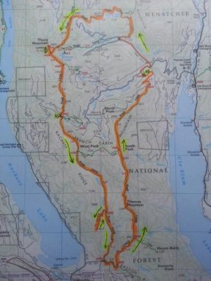
Squamish 50 mile and 50k are difficult courses across the board, run on technical singletrack trails. The 50M starts relatively flat for the first 6 miles and then the final mile, but has lots of climbing in between, with the largest climb being roughly 2500 feet. The 50k course is nearly as difficult, also having flatter sections on the front and back end, but the main climb is near the beginning of the race, as it’s the last 50k of the 50M course, and so is a point to point race, whereas the 50M is a loop. Then there are the brave souls who run the 50/50, 50M on Saturday, 50k on Sunday. New for 2018 is a 23km race on Sunday.

Race Details

50m Detailed Course Description

50k Detailed Course Description

Lessons Learned from Race Reports

  • No poles allowed
  • All 50M runners must start with a headlamp, which you can drop at Aid Station 2 to be transported by the race staff to Aid Station 7
  • Since the 50k is a point to point course, not a loop like the 50M, have your transportation sorted out to the start; there is a race bus that can take you there.
  • Very difficult courses, so you need just as much of a strong mental game as a physical one
  • Exposed sections – wear sunscreen and a hat!
  • Lots of super technical, non-runnable trails
  • Likely to to be hot, having a neck cooler or a buff to help keep you cool on the climbs
  • With how slow the course is, accept that you’ll likely need a headlamp the second time in the evening for the 50M
  • Hard to find a flow in the race because the lack of runnability of so much of the course
  • The terrain makes the course more challenging than the elevation gain
  • Last 10k of the course is very challenging and easy to have a very low point physically and mentally
  • Be sure to carry enough fueling given the slow course and mileage between aid stations
  • Use the course preview runs if you have the chance
  • If you’re in Seattle, trails for good race simulation are Tiger and Rattlesnake for good climbing and power hiking, Poo Poo Point for technical descending, and Shangri La Trail for running faster on both ups and downs
  • Aid Station #1, Canadian Tire, tends to be very crowded for crew, as they are all heading there at the same time and may experience parking delays, so don’t rely too heavily on your crew here
  • Practice technical descents as much as possible
  • Lots of people leave the last aid station (Farside) at mile 43 pushing hard to the finish, and even though there is only “one more climb” up Phlem, there are still climbs on the way to Phlem
  • See Matt K’s race report on the 50/50 for details about the course, the aid, his lessons learned, and what he’d do differently for training to prepare for those hairy, technical descents.

Elevation

Total gain/loss:

50M: 11000/11000

50k: 8500/9000

Total climbs:

50M: 1×2555, 1×1400, 1×900, 1×400, 4×200-400 feet

50k: 1×2600, 1×1400, 3×200-400 feet

Longest climb:

50M: 2555 feet in 6.5 miles from mile 20.7-27.2

50k: 2600 feet in 9.4 miles from mile 0.0-9.4

Steepest climb:

50M: 1223 in 1.7 miles from mile 8.4-10.1 (13.6% grade)

50k: 2037 in 3.3 miles from mile 5.9-9.2 (11.7%grade)

Elevation profile:

50M: http://squamish50.com/wp-content/uploads/2014/11/Squamish50M-1.jpg

50k: http://squamish50.com/wp-content/uploads/2014/11/Squamish50K.jpg


Aid stations

Total aid stations: (50M) 8, (50k) 5

Furthest distance apart: (50M) 7 miles, (50k) 6.2 miles

Locations:

50M: Mile 6 / 12 / 17 / 23 / 30 / 33 / 38 / 43

50k: Mile 5 / 11 / 14 / 20 / 25

What’s available: Mix of Hammergel and Heed electrolyte drink mix, fruits such as oranges, bananas, watermelon, chips, both potato and gluten-free, snacks such as salted pretzels, gummies, cookies, salted potatoes, etc., water and Coke, other gluten-free options

Crew access

50M: Able to crew at AS #1, #2, #5 and #7 (miles 6, 12, 30, and 38)

50k: Able to crew at AS #3 and #5 (miles 14 and 25)

Crew Driving Directions:

50 Mile Start at Squamish Oceanfront to Aid Station #1 at Escape Route

Aid Station #1 at Escape Route to Aid Station #2 at Alice Lake

Aid Station #2 at Alice Lake to Aid Station #5 at Quest

Aid Station #5 at Quest to Aid Station #7 at Far Side

Aid Station #7 at Far Side to Finish Line in downtown Squamish

Pacers

None allowed

Race qualifiers

UTMB – 50M: 4 points, 50k: 3 points, 23k: 1 point

Race reports

50M:

Mark Cliggett’s 2018 50/50 Race Report

Mark Cliggett’s 2018 50/50 Race Report (more detailed)

Matt K’s 2017 50/50 Race report

http://gingerrunner.com/2013/08/27/race-recap-the-squamish-50-miler/ (Check out the likes and dislikes at the bottom of his race report for a summary)

https://krisandnotsodeepthoughts.wordpress.com/2016/08/23/squamish-50-race-report/


50k:

http://jeffpelletier.com/squamish-50k-2014-race-report/

Strava activities and GPX files

50M:

https://www.strava.com/activities/375335917/overview

https://www.strava.com/activities/185426409


50k:

https://www.strava.com/activities/376837387

https://www.strava.com/activities/684412091/overview


Race Website

http://squamish50.com/

GORE-TEX Trans Alpine Run Race Info

Summary: The GORE-TEX Trans Apline Run is a 7 day stage race, comprised of 300 teams of 2 persons, running a total distance of 158.7 miles, starting in Garmisch-Partenkirchen, Germany, crossing the Alps via Austria (stops in Nassereith, Imst, Pitztal and Sölden) and Italy. The route continues from St. Leonhard, stopping next in Sarnthein, before the final day, when the runners cross the finish line in the city of Brixen, South Tyrol (Italy). Each day’s stage is a different distance, a different start time, and therefore different cutoff times throughout each day, as the teams of 2 make their way point to point from Germany to Italy, gaining nearly 54,000 feet of elevation in the process.

Stage Details

  1. Day 1: 27.1 miles, gain/loss of 8,107/7,635 ft
  2. Day 2: 17.5 miles, gain/loss of 5,512/5,653 ft
  3. Day 3: 30 miles, gain/loss of 10,230/7,303 ft
  4. Day 4: 16.9 miles, gain/loss of 7,533/8,602 ft
  5. Day 5: 24.2 miles, gain/loss of 7,375/9,573 ft
  6. Day 6: 21.1 miles, gain/loss of 8,281/7,293 ft
  7. Day 7: 22.4 miles, gain/loss of 6,949/8,307 ft

Further course details, descriptions, and cutoffs noted here.

Lessons Learned from Race Reports

  • Course specific training tips
  • Mandatory Equipment
  • Consider using poles – Steep ascents and descents, with some technical footing throughout
  • Work with partner ahead of each stage to discuss how to approach each day, especially in terms of pacing – when to take it slow and when to run harder
  • Carry a little bit of money during the run in case you have to buy something in towns along the way, or if you need to drop and get to either the next aid station or the final location of the day’s stage.
  • Day 3 is seen as the make it or break it day in the stage run – have some mental strength to get through it and beyond it, and then days 5-7 are “easier” compared to the first few days
  • Notes of sore knees and feet from the pounding of the alpine terrain
  • The course has more “road” running than you would expect, as the route links lots of mountain villages via pavement/paths and ski service roads, so you end up running more road before and after the trail portions than you would expect
  • Incorporate trail runs where you run 2-6 miles of road before and after the trail miles
  • Some of the descents are just as pounding on the legs as the ascents, so keep that in mind when choosing routes for practicing vert, both up and down
  • Practice time on your feet – in many of the race reports, people were averaging 3 miles/hour on most days!
  • Climbs are mainly straight up and straight down
  • Each day’s start tends to be a bottleneck at first, heading out of town and into the uphill single track, so position yourself accordingly if you want to be out front or if you’re a particularly strong climber
  • Be sure to have a good med kit for stuff like upset stomachs, foot care, pain meds, etc., either while you’re out on the course or for each recovery evening between stages
  • Know the cutoffs – some are harder to make than others, because they are based on 5km/hour no matter the elevation profile, so you might spend some time hurrying up and other times taking it easier because of the cutoffs and terrain combo
  • Some good training runs for Seattle locals – the White River training runs July 8th and 15th, 2018, the Squamish ones, or get on the course for the Whistler Alpine Meadows races (55k Strava route here).

Elevation

Total gain/loss: 53,799/54,209

Ft/mile gain: 339 ft/mile

Aid stations

Number of aid stations and locations varies each day, see details on Course page here.

What’s available: Including, but not guaranteed to be the same at each aid station: water, isotonic drinks, coke, tea, coffee, hot chocolate, bread, cheese, salami, vegan spread, energy bars, cake, cookies, fruits, raw vegetables, pickles, pasta, different soups, and potatoes with salt.

Crew access

Race offers a “Family & Friends” Package, with detailed directions to each aid station, as well as other perks. See details here.

Pacers

Pick your running team partner wisely, as they are your pacer!

Race reports

Course specific training tips

Amazing set of race reports from the Preface, packing and through stage 4 (author finished the race but only wrote up through stage 4):

http://brielikethecheese.com/blog/2016/09/transalpine-run-2016-preface/#.Wxn9r4gvw2w

http://brielikethecheese.com/blog/2016/09/transalpine-run-2016-packing/#.Wxn-cYgvw2w

http://brielikethecheese.com/blog/2016/09/transalpine-run-2016-before-the-race/#.Wxn-s4gvw2w

http://brielikethecheese.com/blog/2016/09/transalpine-run-2016-stage-1/#.Wxn-44gvw2w

http://brielikethecheese.com/blog/2016/09/transalpine-run-2016-stage-2/#.Wxn_fIgvw2w

http://brielikethecheese.com/blog/2016/10/transalpine-run-2016-stage-3/#.WxoANogvw2w

http://brielikethecheese.com/blog/2016/11/transalpine-run-2016-stage-4/#.WxoA9Igvw2w

Strava activities and GPX files

GPX files with course data are part of mandatory equipment – as of June 2018, couldn’t locate them on the race website.

Stage 1: https://www.strava.com/activities/700494148

Stage 2: https://www.strava.com/activities/701364866

Stage 3: https://www.strava.com/activities/702812841

Stage 4: https://www.strava.com/activities/703900874

Race Website

https://transalpine-run.com/en/

Prepping for an ultra? Check out our 7 Steps Towards Running your First Ultra!

needles 50k matt urbanski

Needles 50k Race Reports and Info

Summary: The Needles 50k is one burly, beautiful loop starting from Silver Ridge Ranch in Easton, Washington, connecting Domerie Divide, Thomas Mtn, French Cabin Mtn, Little Joe Lake, Thorp Mtn, Kachess Ridge (aka The Cardiac Needles), and Silver Creek, sharing the last ~16 miles of the Cascade Crest 100 course. This course is tough (as only RD-extraordinaire Rich White would have it!). Due to access, there will only be 2 limited aid stations. Think graduate level mountain run. Prerequisite: 50 mile trail run in 12 hours or less. 

Lessons Learned from Race Reports / Important Things to Note

  • Course markings and aid stations are minimal
  • Climbing often seems relentless
  • The climb up to Thorp Mountain (~mile 16) until the 2nd aid station (mile 24.9), where the Cascade Crest 100 course is the same, is the “Needles” section on the CCC 100 course, which is full of steep, technical, exposed climbs and descents, without switchbacks.
  • Course is exposed and above treeline above ~4900-5000 feet, so be ready for full exposure during the day at the top of the climbs around miles 2.5-8 (with some dips in there) and between miles 16 and 22.5
  • Final descent is steep, rocky and rooty at some points and feels really long.
  • Take advantage of the camping included in registration, as you’re right at the start/finish, so no crazy early wake up and drive from Seattle, and bathrooms are at the start (even flushing toilets!) There is also lodging not far away in Cle Elum, including cabins.
  • 1st climb is steep, so be ready to hike and don’t get frustrated at the slow start, as the first 10 miles is the hardest
  • Second half of the course is more runnable if you have your legs under you still
  • Use the creeks and lake after the first aid station to cool off if you feel yourself heating up
  • Pay attention to course markings, especially if running alone. Sharp turn at mile 18.
  • Bring enough water knowing aid is about every 12 miles. If you’re a heavy drinker, tank up, especially with warm, exposed temps.
  • If you’re nervous about getting lost, download the track on your phone so you can track yourself on the course
  • Downhills are deceivingly hard as well, some steep, technical ones throughout
  • If you like poles, this is the kind of course to use them on

Elevation

Total gain/loss: 10,000/10,000

Total climbs: 5 major, countless “minor”

  • 2600ft/2.7 miles
  • 500ft/1 mile
  • 1000ft/2.8 miles (with 2 false summits in between)
  • 2600/8 miles (with 4 false summits before the final summit; final push to summit is about 800ft/1.2 miles
  • 500ft/1.5 miles (with 2 false summits in between)
  • From about mile 22 on, you lose about 2300ft with one small pop of about 200 feet around mile 23

Longest climb: 2600/8 miles (with 4 false summits before the final summit; final push to summit is about 800ft/1.2 miles

Steepest climb: 1400ft/1 mile and 500ft/.4 miles

Elevation profile – see Matt Urbanski’s strava

needles 50k info

(Race starts in Easton on the bottom of the map and heads counterclockwise. Map indicates that Kachess Beacon Trail around mile 29 is part of the course, which it is not)

Aid stations

Total aid stations: 2

Furthest distance apart: 12.5 miles

Locations: Mile 12.4 and 24.9

What’s available: Typical aid station fare like Coke, chips, pb&j. Because this is a minimally supported event, if you need special food, and because of the long distance between aid stations, be prepared to carry much of your own fuel.

Crew access

None

Pacers

None

Race qualifiers

None, but you get to see a lot of the Cascade Crest 100!

Race reports

Needles 50k Race Report – Anson Fatland

Race: Needles 50k Runner: Anson Fatland Race Date: 7/24/2021 Location: Easton, WA Results: 29th OA Strava Activity Link: https://www.strava.com/activities/5681826927/overview 3 Bests – What aspects of the race did you like the most? 1) It is as advertised. It's a super casual, support-yourself, have-fun-in-the-mountains type of race. 2) The course is BEAUTIFUL. 3) The people are wonderful. Rich and his team ...
needles 50k race report

Needles 50k Race Report – Matt U

Race: Needles 50k Runner: Matt U Date: 7/22/17 Location: Easton, WA Results - 6:19, 1st place and CR 3 Bests – what aspects of the race did you like the most I ran well. It's easy to like a race when you manage the day well, you finish strong, and you place well. 🙂 The camping the night before was ...

Needles 50k Race Report – Dan L

Race: Needles 50k Runner: Dan L Date: 7/22/17 Location: Easton, WA Results - 9:46 (seconds? we don't need no stinking seconds) 3 Bests – what aspects of the race did you like the most - Camping before and after was wonderful - Small and super friendly race - Ability to explore new area with great views (Mt Stuart among others) ...

Needles 50k Race Report – Stephanie

Race: Needles 50k Runner: Stephanie Date: 7/22/17 Location: Easton, WA Results - 7:50:38, 2nd female and 8th overall 3 Bests – what aspects of the race did you like the most 1. The whole atmosphere of the race. Small, friendly, relaxed. 2. The final 2/3rds of the course - it seemed so easy relative to the first climb! 3. The ...

Strava activities and GPX files

https://www.strava.com/activities/1096707981

https://www.strava.com/activities/622702551

https://www.strava.com/activities/628019905

Race Website

https://ultrasignup.com/register.aspx?did=51689

Prepping for your first ultra? Check out our 7 Steps Towards Running your First Ultra!

Beat the Bridge 3 mile run info

Date: 5/20/18

Location: Seattle, WA (Husky Stadium at UW)

Start Time: 8:00am

Avg Temps (f): 66/48

Time Limit: N/A, though the race is called Beat the Bridge because 20 minutes after the last 8k runner crosses the starting line, the University Bridge is raised for 5 minutes, then brought back back. The 8k starts at 8:30am.

Lessons Learned from Race Reports

  • Lots of runners for all the events, so advisable to pick your packet up the day before, on Saturday
  • Again, with so many runners in the all the events, it’s likely to be very crowded at the start and in the early miles. Be sure to give yourself plenty of time to get to the event, park, use the bathroom, etc. And be ready to weave in and out of people traffic early on, especially in the 3 mile run, which has more walkers than the 8k event.
  • With the event starting “later” at 8am, well after the sun has been up for a while, even slightly warm temps will make it feel hot, so dress accordingly, and use water at aid stations as you need to cool down (ie, dump water on your head if that’s what it takes!)

Course

Type: Loop

Start/Finish Info: Different locations, but both close to each other and the event parking. Start on Montlake Boulevard and finish on the field of Husky Stadium

Hills: Minimal, with an uphill being from when runners turn off the Burke Gilman bike trail and run up into campus, about halfway through the course, after which they turn around and head back downhill to the stadium.

Map/Elevation


Aid stations

Locations of water/electrolyte stations: Two water and electrolyte stations. See Course map to familiarize yourself with the street locations.

Spectator access

Access Locations: Lots of spots around UW Campus and at the finish at Husky Stadium. Event parking is near Husky Stadium or around UW campus, but be aware of street closures for the 8k event. See course map for more details.

Race reports

https://teamrunrun.com/beat-bridge-8k-milah-f/

http://www.dailygarnish.com/2017/05/beat-the-bridge-8k-2017.html


Race Website

http://www2.jdrf.org/site/TR/Walk/JDRFNorthwestChapter4700?pg=entry&fr_id=7194